Ratholz
Ratholz is a village in the Konstanzer Tal and a district of Immenstadt im Allgäu in the Oberallgäu district , it is located at the western end of the Great Alpsee .
Ratholz is located on the Allgäu Railway and had its own breakpoint until the early 1980s (1982/83).
Walks and sports
In summer
- Via Thaler Höhe to Oberstaufen : Starting point at the parish hall - street towards the railway line ( Bleichgut ) - further towards Reuter - in turns (street) up over the Hohenschwand Alpe to the Thaler Höhe (1,039 m) - either first to the right ( Alpsee view ) and the view after the Great Alpsee or walk straight west - over the Thaler Höhe and the Salmaser Höhe comfortably towards Oberstaufen - return from Oberstaufen train station by bus back to Ratholz (duration of the hike approx. 4 hours, no special requirement, sturdy shoes required)
- Direction Nagelfluhkette : Starting point at the parish hall or the Alpsee-Coaster car park - via serpentines up towards Alpe Bärenfalle (1,100 m) - further east towards Gschwender Horn (1,450 m) and Kemptener Naturfreundehaus (1,450 m) (leisurely half-day tour, sturdy shoes are essential)
- Circular route around the Großer Alpsee : Starting point at the community center - cross under the Queralpenstraße (B 308) - keep left and follow the signs for the Rundweg um den Großer Alpsee - above the road, the path leads over meadows and the so-called Stadtwald past Hintersee towards Gschwend - from there on on the asphalt road through Rieder down to Bühl am Alpsee - in Bühl towards the harbor continue on the promenade - from there always directly along the Alpsee towards Trieblings and back to the starting point (half-day tour, approx. 11 km, sturdy shoes required)
- The so-called Alpseecoaster starts from the Alpen Bärenfalle. A year-round toboggan run on a rail system with speeds of up to 40 km / h. At 2.8 kilometers, it is the longest year-round toboggan run in Germany. There is also a climbing forest in the immediate vicinity of the “Bärenfalle” mountain hut. This bears the title of the largest climbing forest in Bavaria.
In the winter
- Ratholz is the starting point of the 50 km long long-distance hiking trail from the Alpsee to the Waldsee towards Lindenberg . It is only groomed when the snow conditions are very good.
- Skiers got their money's worth in Ratholz until 2016: the Alpe Bärenfalle was the starting point for winter sports. T-bar lifts and chairlifts offered ideal skiing conditions for both beginners and professionals. Only the former valley run has been groomed since 2016 so that it can be used by sledges.
Houses of worship
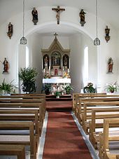
Chapel of St. Martin: After the plans of the Thalkirchdorf master carpenter Joseph Anton Keck were approved, the construction of the chapel of St. Martin in Ratholz was carried out in the summer of 1871 under his direction at the local population's own expense. In autumn one only waited for the consent of the episcopal ordinariate in Augsburg, then on November 28, 1871 the solemn inauguration of the chapel in honor of Saints Wendelin and Martin could take place. After a large-scale renovation in 1983/84, another repair was also completed in 2007. On the neo-Gothic altar from the time it was built there are primarily wooden figures of the two church patrons. Also noteworthy are a late 16th century St. Sebastian from the Bühler Stephanuskirche, as well as a bell from 1685 from the demolished Wendelin chapel with the coat of arms of the Königsegg rule. A picture of the Annunciation by the Bühl-born painter Johann Georg Grimm, which is still attested in 1939, is missing. The chapel is looked after by the parish community Immenstadt - Bühl - Rauhenzell .
literature
- Immenstadt im Allgäu - landscape, history, economy, cultural and religious life over the centuries . (Ed.) Dr. Rudolf Vogel, Verlag J. Eberl KG, Immenstadt 1996.
- Gerhard Klein, chapels in the parish area , in: St. Stephan - Bühl, a living parish of 50 years, ed. v. Parish of St. Stephan, Immenstadt 2007, pp. 17-20
- Compass hiking map No. 3 (Allgäu Alps and Kleinwalsertal) . KOMPASS-Karten GmbH, Innsbruck (A), ISBN 3-85491-005-3 .
Individual evidence
Coordinates: 47 ° 34 ' N , 10 ° 8' E

