
Reddevitz Peninsula
.JPG)
The Reddevitz peninsula, also known as the Reddevitzer Höft , is a headland belonging to the German Baltic Sea island of Rügen . This is part of the Mönchgut peninsula , with which it is connected in the southeast by a 130-meter-wide isthmus . The peninsula is over four kilometers long and only 200 to 500 meters wide. In the west the peninsula ends with the Reddevitzer Höft, whose name is also used for the entire peninsula. At the Reddevitzer Höft the peninsula ends in the west in a steep coast , the heights of which reach over 33 meters. The name of the tip is derived from the Low German "höft" for "head, head". At the eastern end is the village of Alt Reddevitz , part of the Mönchgut community .
To the north of the peninsula is the Having , to the south the Hagensche Wiek , and to the west and southwest is the Greifswalder Bodden .
The peninsula in the Southeast Rügen Biosphere Reserve is largely used for agriculture. The north bank and the western half of the south bank belong to the “Having und Reddevitzer Höft” sub- area of the Mönchsgut nature reserve .
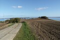
The Reddevitzer Höft
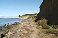
The cliff at the top of the Reddevitzer Höft
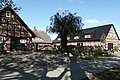
A historic three-sided farm on the peninsula

Colony of rare sand martins


Web links
Coordinates: 54 ° 19 ′ N , 13 ° 39 ′ E