Hagensche Wiek
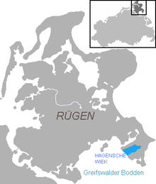
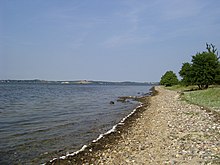
The Hagensche Wiek is a bay in the east of the Ruegen Bodden , which cuts deep into the Mönchgut peninsula , the southeastern tip of Ruegen .
It is about 5 kilometers long, 2.5 kilometers wide and opens towards the southwest to the Rügischer Bodden, the northern part of the Greifswald Bodden . In the north, the Hagensche Wiek is bounded by the narrow, elongated peninsula Reddevitzer Höft , in the south by the “actual” Mönchgut with the up to 66 m high Zicker mountains. In the east, the Wiek approaches the open Baltic Sea not far from the Middelhagen district of Lobbe up to 1000 meters .
The communities of Gager and Middelhagen with the districts of Alt Reddevitz and Mariendorf are located on the Hagenschen Wiek . Gager is the only port in the bay protected by a mole , which is used by fishing and sport boats.
The bay is part of the Southeast Rügen Biosphere Reserve .
literature
- Harald Krause: Wiek and Wikinger - development of shipping and maritime terms of seafarers in the extended Baltic Sea area . In: Bull and Griffin . Sheets on cultural and regional history in Mecklenburg-Western Pomerania , year 19, Schwerin 2009, pp. 10–21. Table: The German Wieken.
Coordinates: 54 ° 18 ′ 45 ″ N , 13 ° 39 ′ 40 ″ E


