
Refuge de La Valette
| Refuge de La Valette PNV hut |
||
|---|---|---|
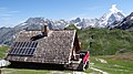
.jpg) The three buildings of the refuge |
||
| location | Department of Savoie ; Auvergne-Rhône-Alpes , France | |
| Mountain range | Vanoise massif | |
| Geographical location: | 45 ° 21 '17 " N , 6 ° 43' 32" E | |
| Altitude | 2590 m | |
|
||
| owner | Vanoise National Park | |
| Construction type | hut | |
| Usual opening times | Mid-June to mid-September | |
| accommodation | 44 beds, 0 camps | |

The Refuge de La Valette is a refuge located in the Savoie department in the Auvergne-Rhône-Alpes region . The refuge belongs to the administration of the Vanoise National Park . It is located in the municipality of Pralognan-la-Vanoise and is a stage destination of the Tour des Glaciers de la Vanoise long-distance hiking trail.
From the hut you have an excellent view of the Grande Casse summit ( 3855 m ), the highest mountain in the Savoie region. The Grand Bec and the Aiguille de Péclet are also clearly visible.
history
_(6).jpg)
The first refuge was built in almost the same place in 1899, but had to be repaired the following spring because a strong storm severely damaged the roof. The ruins are still visible today on the Roc de la Valette.
The refuge in its current form was built in 1971 and expanded in 1983 and 2008.
Approach
The shortest approach is from the hamlet of Prioux, which can be reached from Pralognon via the D124. The entrance to the path ( 1710 m ) is at the level of the hamlet and climbs along the Torrent des Nants to the hostel of the same name. From there, the path climbs another 150 meters in an easterly direction before it bends north and leads almost flat to the hut. Allow about 2h15 for the way.
Alternatively, you can start from Pralognan-la-Vanoise at an altitude of 1450 m . First of all, the path climbs uphill in a number of bends through the forest “foret d'Isertan” towards the summit “Petit Marchet” and then bends below the summit in a south-westerly direction. You should plan around 3h45 for the path, which is almost 1200 meters in altitude.
Tour possibilities
The Dôme des Sonnailles ( 3361 m ) and Dôme de Chasseforêt ( 3586 m ) peaks can be climbed from the refuge . The Refuge du Col de la Vanoise refuge can be reached on a high path .
The hut is also a stage destination on the 75 km Tour des glaciers de la Vanoise hiking trail.
particularities
The refuge consists of 3 buildings. One building contains the kitchen and dining room, a second building offers accommodation for hikers and the third building is reserved for professional mountain guides, the hut keeper and the staff of the Vanoise National Park.

The refuge in front of the summit of the Grand Bec .
The refuge with a view of the Grand Bec and the Grande Casse .

Two of the three buildings.

Refuge.
.jpg)
.jpg)


Web links
- Refuge de La Valette. Vanoise National Park(French).
- Refuge de La Valette. In: camptocamp.org. (French).
- Refuge de La Valette. In: refuges.info. (French).