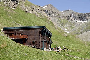
Refuge du Prariond
| Refuge du Prariond PNV hut |
||
|---|---|---|
|
The Refuge du Prariond refuge in summer |
||
| location | Department of Savoie ; Auvergne-Rhône-Alpes , France | |
| Mountain range | Vanoise massif | |
| Geographical location: | 45 ° 27 '20.9 " N , 7 ° 4' 15.6" E | |
| Altitude | 2324 m | |
|
|
||
| owner | Vanoise National Park | |
| Built | 1969 | |
| Construction type | hut | |
| Usual opening times | Mid-June to mid-September | |
| accommodation | 0 beds, 36 camps | |
| Winter room | 16 bearings | |
The Refuge du Prariond is a refuge located in the Savoie department in the Auvergne-Rhône-Alpes region . It is located in the headwaters of the Isère at an altitude of 2324 m in the east of the Vanoise massif . The refuge belongs to the administration of the Vanoise National Park .
history
Before the current refuge was built, there was already a hut approx. 200 m from its current location, the remains of which are still visible today. The ruins are located near the climbing rock used for practice purposes. A cross on a boulder commemorates the “tragédie de la Galise” in which Italian partisans and English soldiers were killed on November 6, 1944 due to extreme weather conditions.
The currently existing hut (as of 2020) was built in 1969 just six years after the Vanoise National Park was established. In 1989 and 1990 the hut was expanded and modernized. The modernization of the hut went hand in hand with an increase in comfort (sanitary facilities, showers, power supply using solar panels).
description
In summer the hut offers 36 beds and in winter 16 beds are available. It is cultivated from the end of March to mid-May and from mid-June to mid-September.
Access
The hut can be reached from the Pont Saint-Charles car park at an altitude of 2058 m , which is about 3 km from Val-d'Isère on the road to Col de l'Iseran . The path, which presents no difficulties at all, leads after an initially steep ascent through the gorge formed by the Isère, the so-called Gorges de Malpasset. For not sure-footed hikers or children, the path is secured with a rope in some places. After the cut has been hiked through, the landscape widens and the hut is already visible. The entire route takes about 1h15 minutes in winter.
Tour possibilities
The hiking trail to the Col de la Galise, which is located at an altitude of 2987 m, starts from the Refuge du Prariond . On the way there, another ascent branches off to Col de la Lose ( 2957 m ). The Italian refuge Rifugio Gian Federico Benevolo can be reached via the Col di Rhemes . The hut is also the starting point for ascents to Pointe de la Galise ( 3343 m ) or the Grande aiguille Rousse ( 3482 m ).
Specialty
Since summer 2010, the hut has also been supplied with electricity by a small hydropower turbine. The turbine was built on the Torrent du Niolet, a tributary of the Isère, and has an output of around 2 kW. The turbine supplements the electricity generated by solar cells.
Web links
- Official website of the Refuge du Prariond.
- Refuge du Prariond. Vanoise National Park(French).
- Refuge du Prariond. In: camptocamp.org. (French).
- Refuge du Prariond. In: refuges.info. (French).

