
Pohraniční
Pohraniční (German Reizenhain , also Bohemian Reizenhain ) is a deserted area directly on the Saxon-Bohemian border in the Czech Ore Mountains . Pohraniční forms a basic settlement unit of the municipality Hora Svatého Šebestiána . The cadastral district covers an area of 1326.9605 ha.
history


_(1).jpg)
Reizenhain was first mentioned in a document from King Wenceslas IV , in which the construction of a road from Prague to Leipzig via Reizenhain was required. The inhabitants of the place lived mainly from the carters passing through. In the 16th century there was a farm in Reizenhain with an inn, flour and sawmill. The owner of the estate also had the privilege of brewing beer.
In 1874 Reizenhain received a railway connection through the Krima – Reitzenhain line of the Buschtěhrad Railway Company (BEB). The border station, however, was built on the Saxon side in Reitzenhain , and a separate stop on the Bohemian territory was only set up later. Since then, Reizenhain's importance for haulage has decreased. Most of the residents now earned their living as forest workers. Due to the rail connection, a modest tourism developed. From the middle of the 19th century Reizenhain formed a community in the judicial district of Sebastiansberg or Komotau district .
After the Second World War, cross-border traffic via Reizenhain came to a complete standstill. The German population of the place was expelled, a resettlement with Czechs was only partially successful. In 1948 the remaining rail traffic from Krima to the Pohraniční stop was stopped. In 1955 the place was officially dissolved.
Today four of the original houses, a chapel and some weekend lots still exist.
Development of the population
|
|
|
Attractions
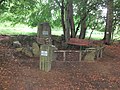
- Stülpnerstein, memorial stone for the Erzgebirge folk hero Karl Stülpner
- Bucheneck, memorial for the Erzgebirge singer and folk poet Anton Günther

Karl Stülpner Memorial in Pohraniční (Bohemian Reizenhain)

Karl Stülpner Memorial in Pohraniční (Bohemian Reizenhain)
Anton Günther Memorial Bucheneck in Pohraniční (Bohemian Reizenhain)

"Bucheneck" stone from the Anton Günther Memorial Bucheneck in Pohraniční (Bohemian Reizenhain)
_(1).jpg)
_(3).jpg)
_(1).jpg)
_(7).jpg)
Individual evidence
- ↑ http://www.uir.cz/katastralni-uzemi/641839/Pohranicni
- ↑ Historický lexikon obcí České republiky - 1869-2015. Český statistický úřad, December 18, 2015, accessed on January 17, 2016 (Czech).
Web links
Coordinates: 50 ° 33 ′ 14 " N , 13 ° 13 ′ 46.2" E