Hora Svatého Šebestiána
| Hora Svatého Šebestiána | ||||
|---|---|---|---|---|
|
||||
| Basic data | ||||
| State : |
|
|||
| Region : | Ústecký kraj | |||
| District : | Chomutov | |||
| Area : | 3439.9534 ha | |||
| Geographic location : | 50 ° 31 ' N , 13 ° 15' E | |||
| Height: | 843 m nm | |||
| Residents : | 318 (Jan. 1, 2019) | |||
| Postal code : | 430 01 - 431 82 | |||
| License plate : | U | |||
| structure | ||||
| Status: | local community | |||
| Districts: | 2 | |||
| administration | ||||
| Mayor : | Jan Koutský (as of 2014) | |||
| Address: | Hora Svatého Šebestiána 3 431 82 Hora Svatého Šebestiána |
|||
| Municipality number: | 563064 | |||
| Website : | www.sebestian.cz | |||
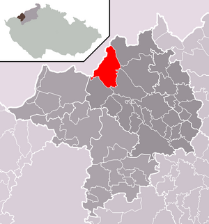
| Location of Hora Svatého Šebestiána in the Chomutov district | ||||

|
||||
Hora Svatého Šebestiána ( German Sankt Sebastiansberg ) is a municipality in Ústecký kraj in the Czech Republic .
geography
location
The village is located in northern Bohemia at 841 m above sea level. M., about 14 kilometers northeast of Chomutov ( Komotau ) on the ridge of the Ore Mountains , on the upper reaches of the Chomutovka ( Komotau or Komotauer Bach ). The Silnice I / 7 runs immediately to the west of the town center and , together with the federal highway 174, which continues on the German side, forms the shortest road connection between the Leipzig-Halle conurbation and Prague .
Community structure
The community Hora Svatého Šebestiána consists of the districts Hora Svatého Šebestiána ( Sebastiansberg ) and Nová Ves ( Neudorf , also Neundorf ). Basic settlement units are Hora Svatého Šebestiána, Jilmová ( Ulmbach ), Nová Ves and Pohraniční ( Bohemian Reitzenhain ).
The municipality is divided into the cadastral districts of Hora Svatého Šebestiána, Jilmová, Nová Ves u Křimova and Pohraniční.
Neighboring places
| Marienberg | Kalek (Kallich) | |

|
Blatno (plates) | |
| Výsluní (Sun Mountain) | Křimov (Krima) |
history

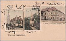
The place was probably founded in 1384 by the Prague citizen and mining entrepreneur Joachim Rothloew , who started looking for ore here with the permission of Emperor Charles IV . The finds were plentiful and the migrating miners founded the first Passberg settlement . In the Middle Ages, the important merchant road from Komotau to Saxony ran through the town . The village was destroyed during the Hussite Wars . In the second half of the 15th century the place belonged to the rule of the Lords of Weitmühl. Sebastian von Weitmühl had the first church of Saint Sebastian built here.
On April 1, 1563, Emperor Ferdinand I confirmed the town's freedoms, namely the salt trade, granted by the previous owners, and granted the town the privilege of two annual fairs, the collection of a carriage duty and a coat of arms. This shows the importance of Sebastiansberg at the time. In 1571 the area belonged to the lords of Lobkowicz and later the Lobkowicz of Hassenstein. These confessed to the Protestants . Recatholization began in 1588 and many residents emigrated to Saxony. In 1593 the place fell to the crown. On January 2, 1597, Emperor Rudolf II named Sebastiansberg a royal mountain town . The place blossomed. In addition to mining, numerous craftsmen settled here. Privileges were also granted by Emperor Matthias in 1616 and by Emperor Leopold I in 1665 .
During the Thirty Years 'War , but also during the Seven Years' War and the Napoleonic Wars , the place was plundered and burned down several times. In addition to the wars, severe winters ensured that the place became increasingly impoverished.
From the middle of the 19th century, Sebastiansberg formed a community in the judicial district of Sebastiansberg or Komotau district , with Sebastiansberg becoming the seat of the district court.
It was not until the 1870s that there was a new upswing. Peat was mined and the basket-making trade, which is still active today, settled. On August 23, 1875 the railway line Komotau – Reitzenhain crossing the Ore Mountains was opened, at which Sebastiansberg received a train station. In 1877 the parish church was rebuilt.
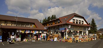
The First World War claimed the lives of many local men. After the war, the inhabitants made a living from smuggling. Due to the Munich Agreement Sebastiansberg belonged from 1938 to 1945 for the district of Chomutov , Region of Usti nad Labem , in the Reich District of Sudetenland the German Reich . After the end of the Second World War , the Germans were expropriated and expelled , and the place had only 150 inhabitants. Today the place lives mainly from tourism. There is a border crossing to the German town of Reitzenhain .
Demographics
Until 1945, Sebastiansberg was predominantly populated by German Bohemia , which were expelled.
| year | population | Remarks |
|---|---|---|
| 1830 | 1292 | in 186 houses |
| 1845 | 1588 | German residents, in 193 houses, including nine Protestant families |
| 1869 | 1743 | |
| 1880 | 2050 | |
| 1890 | 2142 | |
| 1900 | 1995 | German residents |
| 1910 | 1824 | |
| 1821 | 1389 | |
| 1930 | 1322 | |
| 1939 | 1226 |
| year | 1950 | 1961 1 | 1970 1 | 1980 1 | 1991 1 | 2001 1 | 2011 2 |
| Residents | 276 | 524 | 486 | 368 | 180 | 219 | 266 |
coat of arms
The city coat of arms is a vertically divided shield, above which a red archduke hat with a gold cross is depicted. The left half of the shield is again divided horizontally and contains the mining emblems in the lower yellow field, and in the upper two red bars separated by a white one. The right, red half of the shield shows the image of St. Tied to a tree and pierced by five arrows. Martyr Sebastian .
Personalities
- Josef Hemmerle (1914–2003), German historian and archive manager
- Rudolf Hemmerle (1919–2013), German writer
traffic
The R7 expressway runs through the municipality . Due to the recent re-routing as a bypass road for the towns of Nová Ves, Křimov, Domina and Krásna Lípa, the street prostitution that was previously widespread near and in these towns has largely come to a standstill.
tourism
The Bohemian route of the European long-distance path E3 runs through Hora Svatého Šebestiána .
Attractions
- Nikolaistollen show mine (Mikulášská štola), to be visited by appointment.
Web links
- Homepage (German)
Individual evidence
- ↑ http://www.uir.cz/obec/563064/Hora-Svateho-Sebestiana
- ↑ Český statistický úřad - The population of the Czech municipalities as of January 1, 2019 (PDF; 7.4 MiB)
- ↑ http://www.uir.cz/casti-obce-obec/563064/Obec-Hora-Svateho-Sebestiana
- ↑ http://www.uir.cz/zsj-obec/563064/Obec-Hora-Svateho-Sebestiana
- ↑ http://www.uir.cz/katastralni-uzemi-obec/563064/Obec-Hora-Svateho-Sebestiana
- ^ A b Johann Gottfried Sommer : The Kingdom of Bohemia . Volume 14: Saaz District , Prague 1846, pp. 160–163.
- ↑ a b Jaroslaus Schaller : Topography of the Kingdom of Bohemia . Volume 7: Saatzer Kreis , Prague and Vienna 1787, p. 172, paragraph 23).
- ↑ a b Meyer's Large Conversation Lexicon . 6th edition, Volume 18, Leipzig and Vienna 1909, p. 235.
- ↑ Yearbooks of the Bohemian Museum of Natural and Regional Studies, History, Art and Literature . Volume 2, Prague 1831, p. 198, item 7) below.
- ^ A b Michael Rademacher: German administrative history from the unification of the empire in 1871 to the reunification in 1990. Komotau district. (Online material for the dissertation, Osnabrück 2006).
- ↑ Historický lexikon obcí České republiky - 1869–2015. (PDF) Český statistický úřad, December 18, 2015, accessed on January 19, 2016 (Czech).


