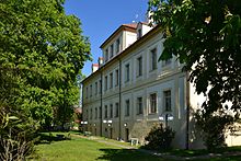
Údlice
| Údlice | ||||
|---|---|---|---|---|
|
||||
| Basic data | ||||
| State : |
|
|||
| Region : | Ústecký kraj | |||
| District : | Chomutov | |||
| Area : | 1186.1051 ha | |||
| Geographic location : | 50 ° 27 ' N , 13 ° 28' E | |||
| Height: | 287 m nm | |||
| Residents : | 1,249 (Jan 1, 2019) | |||
| Postal code : | 431 41 | |||
| License plate : | U | |||
| structure | ||||
| Status: | local community | |||
| Districts: | 2 | |||
| administration | ||||
| Mayor : | Miloš Pavlík (as of 2007) | |||
| Address: | Náměstí 12 431 41 Údlice |
|||
| Municipality number: | 563382 | |||
| Website : | www.obec-udlice.cz | |||
| Location of Údlice in the Chomutov district | ||||

|
||||
Údlice (German Eidlitz ) is a municipality in Okres Chomutov in the Czech Republic .
Geographical location
The village is located in northern Bohemia, southeast of Chomutov ( Komotau ) on the Komotau stream.
Community structure
The municipality Údlice consists of the districts Přečaply ( Pritschapl ) and Údlice ( Eidlitz ), which also form cadastral districts.
History of Eidlitz
The village has its origins in the 12th century, when it probably belonged to the Benedictine monastery Teplitz . The brothers Friedrich and Dietrich von Schönburg are listed as the oldest owners in the annals of the community . In 1295 they created a register in which sales of places to German knights were recorded.
Until the middle of the 14th century the village belonged to Jan Haugwitz . In 1446 Mikuláš and Jan von Lobkowitz bought it. The Lobkowitz family held Eidlitz until the end of the 16th century. In 1469 the village was declared a market town by King George of Podebrady . In 1539 it was elevated to the status of town. From 1594 to 1606 Eidlitz was under the direction of the royal chamber. On December 19, 1605 it passed to Adam Hrzan von Harasov . For the next 250 years the place was under the influence of the lords on Rothenhaus . The castle was built from 1692 to 1695 by Count Ernst Karl Hržan von Harras.
According to the construction books, there was already a branch church in Eidlitz in 1370. From 1609 to 1620 it was occupied by Protestant pastors. In 1672 the church was rebuilt and expanded considerably on this occasion. In 1789 it was elevated to a parish church.
In 1620 the village was attacked and robbed by 100 Bavarian horsemen. Then they set fire to the church and the castle. The worst time for the community was during the Thirty Years' War, when it was robbed several times by Sweden. In 1625, 350 people died of cholera.
In 1790 the city became a free royal city . In 1848 Komotau took over the administration. Agriculture still predominated in the course of the 18th century. Gradually, however, other businesses were added, a sugar factory, a ceramics factory and a mine. At that time there were about 2000 inhabitants in the city. A post office was set up in the village in 1863, the telegraph office in 1895, and in 1912 it was connected to the electricity network.
Until the Second World War , mostly Germans lived in the village. Due to the Munich Agreement Eidlitz belonged from 1938 to 1945 for the district of Chomutov , Region of Usti nad Labem , in the Reich District of Sudetenland the German Reich . After the end of the Second World War, Czech and Slovak settlers came.
Pritschapl
The parish church of St. Matthew in Přečaply ( Pritschapl ) stands on a hill, 301 meters above sea level. The first mention is said to be from the 11th century. In the Heimatbuch of 1888 it is mentioned that the church is under imperial patronage. The altar arch is inscribed with the words God be with us and we in God . The last Mass was held there on May 23, 1969.
Demographics
Until 1945, Eidlitz was mostly populated by German Bohemia , which were expelled.
| year | Residents | Remarks |
|---|---|---|
| 1845 | 755 | in 143 houses, including 40 houses with Israelite families |
| 1850 | about 800 | |
| 1930 | 2452 | |
| 1939 | 2201 |
| year | 1950 | 1961 | 1970 | 1980 | 1991 | 2001 | 2011 |
|---|---|---|---|---|---|---|---|
| Residents | 1182 | 1250 | 1051 | 856 | 842 | 873 | 917 |
Attractions
- Údlice Castle
- Exaltation of the Cross Church
- New Jewish cemetery
Web links
Individual evidence
- ↑ http://www.uir.cz/obec/563382/Udlice
- ↑ Český statistický úřad - The population of the Czech municipalities as of January 1, 2019 (PDF; 7.4 MiB)
- ↑ http://www.uir.cz/casti-obce-obec/563382/Obec-Udlice
- ↑ http://www.uir.cz/katastralni-uzemi-obec/563382/Obec-Udlice
- ↑ a b Jaroslaus Schaller : Topography of the Kingdom of Bohemia . Volume 7: Saatzer Kreis , Prague and Vienna 1787, pp. 195–196, paragraph 16.
- ↑ a b c Johann Gottfried Sommer : The Kingdom of Bohemia . Volume 14: Saaz Circle , Prague 1846, pp. 140-141, item 7).
- ^ Homeland Komotau of the Sudeten German Landsmannschaft
- ↑ Topographic Lexicon of Bohemia . Prga 1852, p. 88, bottom left column .
- ^ A b Michael Rademacher: German administrative history from the unification of the empire in 1871 to the reunification in 1990. Komotau district. (Online material for the dissertation, Osnabrück 2006).
- ↑ Schloss Eidlitz (accessed March 5, 2017)


