
Klášterec nad Ohří
| Klášterec nad Ohří | |||||
|---|---|---|---|---|---|
|
|||||
| Basic data | |||||
| State : |
|
||||
| Region : | Ústecký kraj | ||||
| District : | Chomutov | ||||
| Area : | 5379.9503 ha | ||||
| Geographic location : | 50 ° 23 ' N , 13 ° 10' E | ||||
| Height: | 320 m nm | ||||
| Residents : | 14,533 (Jan 1, 2019) | ||||
| Postal code : | 431 51 | ||||
| License plate : | U | ||||
| traffic | |||||
| Railway connection: | Chomutov – Cheb | ||||
| structure | |||||
| Status: | city | ||||
| Districts: | 12 | ||||
| administration | |||||
| Mayor : | Štefan Drozd | ||||
| Address: | nám. Dr. Eduarda Beneše 85 431 51 Klášterec nad Ohří 1 |
||||
| Municipality number: | 563129 | ||||
| Website : | www.muklasterec.cz | ||||
| Location of Klášterec nad Ohří in the Chomutov district | |||||

|
|||||


Klášterec nad Ohří (German Klösterle an der Eger ) is a town in the Okres Chomutov in the Czech Republic .
geography


Geographical location
The city is located in northwestern Bohemia in the valley of the Eger , on its left bank, between the Ore Mountains and the Duppau Mountains . The Breite Bach flows into the Eger here.
Community structure
It consists of the districts Ciboušov ( Ziebisch ), Hradiště ( Radis ), Klášterec nad Ohří ( Klösterle an der Eger ), Klášterecká Jeseň ( Geßeln ), Lestkov ( Leskau an der Eger ), Mikulovice ( Niklasdorf ), Miřetice u Klášdorf Meretitz ), Rašovice ( Roschwitz ), Suchý Důl ( Dörnthal ), Šumná ( Schönburg ), Útočiště ( refuge ) and Vernéřov ( Wernsdorf ). Basic settlement units are Ciboušov, Holubí vrch, Horní Miřetice ( Obermeretitz ), Hradiště ( Radis ), K Ciboušovu, Klášterec nad Ohří-střed, Klášterecká Jeseň, Kunov ( Kunau ), Vysoké ( Nadýštětočkov ), Lestřovice Neuwernsdorf ), Pavlov ( Ahrendorf ), Petlérská-východ ( beggars ), Petlérská-západ ( beggars ), Pod Šumnou, Pod vyhlídkou, Potočná ( Schönbach ), Rašovice, Staré Miřetice ( Alt-Meretitz ), Suchý Důl, Šumná ( Schönburg ) , U Kláštereckého potoka, U Ohře, U třešňovky, Útočiště, Velká Lesná ( Großspinnelsdorf ), Vernéřov and Za starou porcelánkou.
The municipal area is divided into the cadastral districts of Hradiště u Vernéřova, Klášterec nad Ohří, Klášterecká Jeseň, Kunov, Lestkov u Klášterce nad Ohří, Mikulovice u Vernéřova, Miřetice u Klášterova, Miřetice u Klášterce nad Uřadov, Klášterce nad Ohřadí, Klášterce nad Uřadov, Klášterce nad Vernénáter, Klášterce nad Uřadov, Klášterce nad Ohřadova, Klášterce nad Ohřadova, Klášterce nad Ohří Suchý Důl u Klášterce nad Ohří, Velká Lesná and Vernéřov.
Neighboring places
| Měděnec (Copper Mountain) | Domašín (Tomichan) | Výsluní (Sun Mountain) |
| Perštejn (Pürstein) |
.svg)
|
Kadaň (Kaaden) |
| Okounov (Okenau) | Hradiště military training area |
history


In the 12th century members recruited from the House of Přemyslid by locators German settlers in the almost uninhabited border region. The settlers were granted privileges and the landowners promised themselves economic benefits through their services. The place was first mentioned in writing in 1352. At the time of the built Benedictine Order from the monastery Postelberg of a provost , which was disbanded in the 13th century. After the end of the Saxon Fratricidal War , Apel Vitzthum the Elder was expelled from Roßla in 1452 and found a new basis for life in Bohemia in 1453 as a council of the local king and also acquired the manors of Klösterle and Neuschönburg .
As a result of the changed political situation after the Battle of the White Mountain in the Thirty Years' War in 1621, the Thun and Hohenstein family were able to acquire Klösterle Castle and other lands and they kept these until the middle of the 20th century until the end of World War II in May 1945. The last owner of Schloss Klösterle was Matthias Graf von Thun-Hohenstein. Under her rule, the baroque church "The Most Holy Trinity" was built, the castle was rebuilt in the neo-Gothic style and the castle park was completed as an English landscape garden with a sala terrena .
After the establishment of the first porcelain factories in Bohemia in 1792 in Schlaggenwald and in 1794 by Johann Nikolaus Weber (1734–1801), chief forest master and chief director of the Count Thun's lordship in Klösterle an der Eger, the city gained in economic importance. The factory was leased from Christian Nonne (1733–1813), founder of the porcelain factory Gießhübel near Luditz, and made beautiful porcelain, decorated and decorated. a. from the porcelain painter Anton Nabichl (* around 1840), that it became known throughout the Habsburg monarchy . The son of Johann Nikolaus Weber, Josef Weber, born on February 3, 1855 in Klösterle, took over the Sauerbrunn from the municipality on lease and made sure that the "Klösterle Sauerbrunn" became known on the markets, acquired the "Weberschaner Sauerbrunn" and the "Bitterwasserquelle Pullna" and began to turn Klösterle into a health resort.
In 1918 Klösterle became part of the newly created Czechoslovakia . As part of the Munich agreement , the city was the German Reich awarded, and it belonged from 1938 to 1945 for the district Kadan , Region of Eger , in the Reich District of Sudetenland . After the Second World War , the German-speaking residents were expelled as part of the Beneš decrees . The railroad transports of the displaced went via the Cheb (Eger) train station to Bavaria.
Porcelain is still produced in the city today under the “THUN” brand, based on the Thun-Hohenstein founding family.
District Hradiště (Radis)
A water treatment plant with energy generation from the Preßnitz reservoir has been operating in the Hradiště district since 1976 . The water from the dam mainly supplies the towns of Klösterle an der Eger, Kaaden, Komotau and Brüx with drinking water. see: Preßnitz dam # water treatment plant in Hradiště and supply area of the dam
Felixburg Castle in the Rašovice district (Roschwitz)
In 1576 Bohuslaw Felix von Lobkowitz near Roschwitz built the Renaissance Felixburg Castle, which was named after him. His wife Anna, née von Vitzthum , used the castle as a widow's residence and also died here. In 1588 Bohuslaw Joachim von Lobkowitz sold the castle to Wolf Soldan von Steinbach (Štampach). When the latter was unable to raise the purchase price, the castle immediately returned to the Lobkowitz's possession. In 1593 the castle was transferred to Magdalena von Salm . In 1596 she sold it to Leonhard von Steinbach , master of Egerberg Castle . In 1623 the Counts of Thun and Hohenstein received the rule of Klösterle with the castles of Klösterle and Felixburg. The Felixburg renaissance castle was used as a civil servant's residence until 1777. In 1777 the renaissance castle burns down. It is then partially restored, apparently in the baroque or late baroque style. In 1870 it was already uninhabited. In the square courtyard there were arched arcade galleries on three sides . The walls in the courtyard were decorated with frescoes depicting women and rabbits. Therefore the people called the castle "Hasenburg". In 1874 the event took place that sealed the end of the castle: the Thun'sche official administration in Klösterle sold the castle's roof and woodwork. After that, the stones were apparently transported away for building purposes or stolen. Around 1900 there were only minor ruins left. Viktor Karell also tells the legend "The Felixburg Castle".

Felixburk Castle in the 18th century

Ruins of the castle around 1900
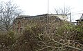
Remains of the walls of Felixburk Castle preserved in 2004


Demographics
Until 1945, Klösterle on the Eger was predominantly populated by German Bohemia , which were expelled in the course of the Beneš decrees .
| year | Residents | Remarks |
|---|---|---|
| 1785 | k. A. | 165 houses |
| 1830 | 1,034 | in 177 houses |
| 1843 | 1,162 | in 179 houses, exclusively German residents |
| 1900 | 2,768 | German residents |
| 1921 | 2,452 | thereof 2,403 (98%) Germans |
| 1930 | 2,226 | thereof 41 (2%) others |
| 1939 | 2,500 |
| year | 1950 | 1961 | 1970 | 1980 | 1991 | 2001 | 2011 |
| Residents | 1,593 | 2,022 | 3,590 | 4.147 | 6,624 | 6,486 | 5,922 |
Attractions


- Klösterle Castle with Sala terrena and castle park as well as porcelain museum
- Trinity Church by Carlo Lurago with Thunscher's burial chapel
- numerous saints sculptures at the Trinity Church
- Market square with reconstructed town houses, fountain and Holy Trinity column
- Pilgrimage church "Maria Trost" and cemetery chapel at the cemetery of Johann Christoph Kosch (around 1760)
- Eugenie Spa (Lázně Evženie) with spa facilities and three mineral springs with high lithium content:
- Eugenie spring from 12 m depth
- Klášterec spring from a depth of 120 m
- City spring from 90 m depth
- Sauerbrunnen from 1898 - on the way to Rašovice (Roschwitz) near the Eger
- in the Rašovice district there are small remains of the Felixburk / Felixburg castle.
- south of Rašovice and east of Lestkov (Leskau) there are small remains (soil monument) of the Funkštejn castle on a mountain slope.
- northwest of the district of Lestkov (Leskau) are the important ruins of the late Gothic castle Egerberk (Egerberg).
- Niklasdorf deserted area : in the isolated district of Niklasdorf (Mikulovice), west of Klösterle, there is the preserved village church “Saint Nicholas” (under restoration in 2018) with remains of the cemetery. At least two monuments from Niklasdorf (including St. Nepomuk) were moved to the town of Klösterle in front of the Trinity Church.
- Bunker line (before 1938) as part of the Czechoslovak Wall north of Lestkov (Leskau) on the mountain slope above the south side of the Eger
- to the west of Klösterle are the ruins of the Šumburk (Schönburg, also called Neuschönburg) on the Šumná mountain .
- Vernéřov castle ruins, few remains.
Community partnerships
- Baarn , Netherlands
- Großrückerswalde , Germany
Personalities
sons and daughters of the town
- Sigmund von Thun and Hohenstein (1827–1897), politician, governor of the emperor in Moravia and state president of Salzburg
- Eduard Enzmann (1882–1965), landscape painter; born in Wernsdorf-Faberhütten
- Meinrad Langhammer (1884–1942), military chaplain
- Rudolf Langhammer (1889–1958), teacher, archivist and historian
- Jane Darling (* 1980), porn actress
- Josef Hoßner (born September 5, 1874 in the district of Leskau ad Eger, † December 21, 1935 in Preßnitz ), teacher / senior teacher in Preßnitz and local history researcher for the area around Preßnitz. Chronicler of the city of Preßnitz. The "Hoßner-Allee" from Preßnitz to Reischdorf was named after him. Author of several books on local history, a. a. "Chronicle of Christofhammer", "Legends of the Preßnitz district", "The castles of our homeland", "Around the copper hill", "Home booklet of the Preßnitz district". Employee of the "Erzgebirgszeitung". Chairman of the Erzgebirgsverein (for signposting hiking trails) and other associations.
People related to the city
- Johann Brokoff (1652–1718), carver and sculptor, lived in the village from 1685–1687 at the invitation of Oswald von Thun and created allegorical sculptures (Trition sculpture in the castle, four seasons, bust of the three Turks)
- Carl Immanuel Löscher (1750–1813), designer and inventor of the mammoth pump , was a miner at the Count of Thun's Mining Authority until 1793
- Karl Venier (1812–1876), pioneer of the Bohemian porcelain industry and inventor of a gas-fired porcelain kiln, died here
literature
- Viktor Karell : Castles and palaces of the Ore Mountains and Egertal. Vol. 1, Vinzenz Uhl Verlagbuchhandlung , Kaaden , 1935 ("Die Felixburg" pp. 49–50; "Schloß Klösterle" pp. 41–43)
- Viktor Karell : The middle, Egertal and the history of the city of Klösterle on the Eger in the Sudetenland, Verl. Das Viergespann, Frankfurt / Main, 1961, FRG.
- Anton Panhans: From the Egertal near Klösterle, Verl. Das Viergespann, Frankfurt / Main, 1965, FRG.
- Rudolf Langhammer: "The castles of the middle Egertal and the town of Klösterle", Verlag Neuber, Klösterle 1934
Web links
Individual evidence
- ↑ http://www.uir.cz/obec/563129/Klasterec-nad-Ohri
- ↑ Český statistický úřad - The population of the Czech municipalities as of January 1, 2019 (PDF; 7.4 MiB)
- ↑ http://www.uir.cz/casti-obce-obec/563129/Obec-Klasterec-nad-Ohri
- ↑ http://www.uir.cz/zsj-obec/563129/Obec-Klasterec-nad-Ohri
- ↑ http://www.uir.cz/katastralni-uzemi-obec/563129/Obec-Klasterec-nad-Ohri
- ↑ Various authors (including Stanislav Ded): Přísečnice - zatopena, ale nezapomenuta / Preßnitz - lost but not forgotten ; Anthology, Chomutov Regional Museum, 2004, no ISBN. Pressnitz statue of the Madonna from 1699 in the town of Klösterle an der Eger, illustration on p. 69 (Czech / German).
- ↑ Hans-Ulrich Engel: Burgers and castles in Bohemia . Based on old templates, Frankfurt am Main, 2nd edition 1978, p. 123
- ↑ Josef Weinmann: Egerländer Biografisches Lexikon with selected people from the former Reg.-Bez.Eger , Volume 2, Bayreuth 1987, p. 293
- ↑ Waltraud Neuwirth: Porzellanmaler-Lexikon, Vol. 1, 1977
- ^ Statistical information service of the State Commissioner for Refugees in Bavaria, edited by Dr. Martin Kornrumpf in Munich on the official figures on the refugee problem in Bavaria; Alfred Bohmann : The Sudeten Germanism in numbers. Handbook on the existence and development of the Sudeten German ethnic group in the years from 1910 to 1950. The cultural, sociological and economic conditions in the mirror of statistics, Munich 1950, p. 253 ff.
- ↑ Zdena Binterová: Chapter "The Preßnitzer Dam" in: Přísečnice - zatopena, ale nezapomenuta / Preßnitz - sunk but not forgotten ; Anthology, Chomutov Regional Museum, 2004, no ISBN. Pp. 102-104 (Czech / German).
- ↑ Viktor Karell : Castles and palaces of the Ore Mountains and Egertal. Vol. 1, Vinzenz Uhl Verlagbuchhandlung , Kaaden , 1935. ("Die Felixburg" pp. 49–50)
- ↑ Viktor Karell : Castles and palaces of the Ore Mountains and Egertal. Vol. 1, Vinzenz Uhl Verlagbuchhandlung , Kaaden , 1935. Legend about Felixburg p. 100
- ↑ Jaroslaus Schaller : Topography of the Kingdom of Bohemia . Volume 7: Saatzer Kreis , Prague and Vienna 1787, pp. 143–146 .
- ↑ Yearbooks of the Bohemian Museum of Natural and Regional Studies, History, Art and Literature . Volume 2, Prague 1831, p. 199, item 12
- ↑ Johann Gottfried Sommer : The Kingdom of Bohemia . Volume 14: Saaz Circle , Prague 1847, p. 199, item 1).
- ^ Meyer's Large Conversational Lexicon . 6th edition, Volume 11, Leipzig and Vienna 1907, p. 157 .
- ^ Ernst Pfohl: Ortlexikon Sudetenland. Helmut Preußler Verlag-Nürnberg. 1987. Page 244. ISBN 3-925362-47-9
- ^ Rudolf Hemmerle : Sudetenland Lexikon Volume 4, page 240. Adam Kraft Verlag, 1985. ISBN 3-8083-1163-0 .
- ^ Michael Rademacher: German administrative history from the unification of the empire in 1871 to the reunification in 1990. Kaaden district. (Online material for the dissertation, Osnabrück 2006).
- ↑ Various authors (including Stanislav Ded): Přísečnice - zatopena, ale nezapomenuta / Preßnitz - lost but not forgotten ; Anthology, Chomutov Regional Museum, 2004, no ISBN. Josef Hoßner, p. 106 (Czech / German).