
Postoloprty
| Postoloprty | |||||
|---|---|---|---|---|---|
|
|||||
| Basic data | |||||
| State : |
|
||||
| Region : | Ústecký kraj | ||||
| District : | Louny | ||||
| Area : | 4651.6716 ha | ||||
| Geographic location : | 50 ° 22 ' N , 13 ° 42' E | ||||
| Height: | 193 m nm | ||||
| Residents : | 4,716 (Jan 1, 2019) | ||||
| Postal code : | 439 42-440 01 | ||||
| License plate : | U | ||||
| traffic | |||||
| Railway connection: | Postoloprty – Louny | ||||
| structure | |||||
| Status: | city | ||||
| Districts: | 13 | ||||
| administration | |||||
| Mayor : | Zdeněk Pištora (status: 2014) | ||||
| Address: | Mírové náměstí 318 439 42 Postoloprty |
||||
| Municipality number: | 566624 | ||||
| Website : | www.postoloprty.cz | ||||
| Location of Postoloprty in the Louny district | |||||

|
|||||


Postoloprty (German Postelberg ) is a town in Okres Louny (Laun district) in the north-west of the Czech Republic .
Geographical location

The city is located in the north-west of Bohemia , seven kilometers west of the city of Louny ( Laun ).
history


The place was first mentioned in the Chronica Boemorum des Cosmas of Prague as a village next to the Benedictine monastery of the Virgin Mary .
The Slavic fortress Draguš , located about 600 m southwest of the town on the Eger and built by the Přemyslids on an area of the Lutschanen tribe conquered by them , is also mentioned by Cosmas.
The monastery, whose founder and date of foundation (before 1119) are not exactly known, was later named Porta Apostolorum . The place name is said to have originated from this monastery name through corruption . The monastery, along with a rich library containing valuable manuscripts, was burned down by the Hussites in May 1420 and never rebuilt. The monastery property and rule were transferred by King Georg von Podiebrad to his sons in 1454, from whom it was acquired in 1480 by the Freiherr von Weitmühl . Sebastian von Weitmühl campaigned for Postelberg to receive the status of a subject town from King Ladislaus II .
Under Ferdinand von Schwarzenberg , who had owned the estate since 1692, Postelberg developed into a center of the extensive estates, which in 1846 comprised 11,500 hectares. They remained in the possession of the Schwarzenberg family until they were expropriated in 1945.
After the First World War , Postelberg was added to the newly founded Czechoslovakia . In 1930 Postelberg had 3,300 inhabitants, most of whom were of German descent. After the Munich Agreement Postelberg came in 1938 to the German Reich and was until 1945 the district Saaz , Region of Eger , in the Reich District of Sudetenland . After the Second World War , Postelberg was taken over by Czechoslovakia. Most of the German residents were expropriated and expelled by 1946 .
Postelberg, together with the city of Brno, suffered the highest loss of German human life during displacement. According to the Beneš decree 108 of October 25, 1945, the property of the German residents was confiscated and placed under state administration.

Parts of the former monastery complex
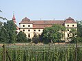
lock
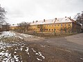
Former barracks on the southern outskirts

Access to the abandoned barracks buildings


Postelberg massacre
After the Soviet troops present since May 8 had withdrawn, at least 763 German men and boys aged 12 to over 60 were tortured and shot in a pogrom between June 3 and 7, 1945 on the barracks grounds. Most of them came from the neighboring town of Saaz ( Žatec ) and were driven here on June 3rd on a death march . The massacre committed by the First Czechoslovak Division under General Oldřich Španiel was dealt with in 1947 by a parliamentary commission of inquiry which recommended the exhumation and cremation of the murdered. The Beneš decree 115/46 declared actions like this massacre until October 28, 1945 in the struggle to regain freedom, ... or which aimed at just retribution for acts of the occupiers or their accomplices, ... as not unlawful.
In November 2009 the City Council of Postoloprty decided to erect a memorial for the victims of the massacre and similar events , which should bear the inscription “All innocent victims of the events in Postelberg in May and June 1945”. A plaque with this text was unveiled on June 3, 2010 in the Postoloprty cemetery.
Demographics
| year | Residents | Remarks |
|---|---|---|
| 1785 | k. A. | 142 houses including a Judengasse |
| 1828 | 1,125 | |
| 1830 | 1,190 | in 153 houses |
| 1843 | 988 | in 114 houses, including the 14 houses in Judengasse where 39 Jewish families lived |
| 1900 | 3,556 | predominantly German residents |
| 1921 | 3,379 | including 3,157 German residents |
| 1930 | 3,311 | |
| 1939 | 2,563 |
| year | 1950 | 1961 | 1970 | 1980 | 1991 | 2001 | 2011 |
| Residents | 2,366 | 2,268 | 3,254 | 3,572 | 3,575 | 3,835 | 3,697 |
Local division
The town of Postoloprty consists of the districts Březno ( Priesen ), Dolejší Hůrky ( Horka ), Hradiště nad Ohří ( Hraidisch ), Levonice ( Lewanitz ), Malnice ( Malnitz ), Mradice ( Mraditz ), Postoloprty ( Postelberg ), Rvenice ( Ferbenz ) Seletice ( Selletitz ), Seménkovice ( Semenkowitz ), Skupice ( Skupitz ), Strkovice ( Sterkowitz ) and Vrbka ( Ferbka ). The urban area is divided into the cadastral districts of Březno u Loun, Dolejší Hůrky, Hradiště nad Ohří, Levonice, Malnice, Mradice, Postoloprty, Rvenice, Seménkovice, Skupice u Postoloprt, Strkovice and Vrbka u Postoloprt.
The basic settlement units are Březno, Březno-u cukrovaru, Dolejší Hůrky, Draguš, Hradiště, Levonice, Malnice, Mradice, Nové Postoloprty, Pod Draguší, Postoloprty-střed, Průmyslový obvod-sever, Průmyslový obvod-sever, Průmyslovice obvod-sever, Průmice-zlový obvod-sever, Průmyslovákový obvod-sever, Průmyslovice Strkovice, Stříbrník, Šafranice, U hřbitova, U Ohře, U statku and Vrbka.
Attractions
- A castle was built on the site of the monastery from 1611 , which was rebuilt in Baroque style from 1706–1718 according to plans by Paul Ignaz Bayer .
- The Church of the Assumption was built in 1753 according to plans by Andrea Altomontes.
- An archaeological open-air museum is located southwest of the place in the area of the village Březno / Priesen on the Egerufer. It shows a settlement that was used from the Neolithic to the Germanic and early Slavic epochs. Not far from there is another late Neolithic to Bronze Age settlement Na Šachtach , which is part of the national cultural heritage of the Czech Republic.
- Not far from the museum is a protected geological outcrop in connection with the appearance of the Bohemian Chalk ( Priesener layers ).
geology
The Priesener layers (Czech: Březenské souvrství ) were named after today's district of Březno (Priesen) . It is a lithostratigraphic technical term for deposits in the area from the middle Coniacium to the lower Santonium within the Cretaceous period . They consist of the marly clays typical for them , as well as limy marls and tarpaulins . In the upper layers there are sometimes concretions of siderite and pyrite . The ammonite genus Baculites is one of the striking fossil deposits , which is why we used to speak of baculite marl or baculite clays .
At Březno this sequence of layers reaches a thickness of over 500 meters. Here they form the main part of the Kreuzberg (Březenský vrch) on the right bank of the Eger. The deposit has been a protected state natural monument since 1998 because of its paleontological and stratigraphic features.
Sons of the city
- Johann I (Schwarzenberg) (1742–1789), German-Bohemian prince
- Anton Langweil (1791–1837), Bohemian painter and model maker
- Julius Anton Glaser (1831–1885), Austrian legal scholar and liberal politician, Minister of Justice
- Friedrich Balling (1834–1896), mountain director in Schwarzbach
- Eduard Bacher (1846–1908), Austrian journalist
- Ernst Viktor Zenker (1865–1946), Austrian journalist and parliamentarian
- Ludwig Freund (1878–1953), physician and zoologist in Prague, concentration camp survivor
- Norbert Josef Pitrof (1907–1995), painter and model railroader
literature
- Joachim Bahlcke , Winfried Eberhard, Miloslav Polívka (eds.): Handbook of historical places . Volume: Bohemia and Moravia (= Kröner's pocket edition . Volume 329). Kröner, Stuttgart 1998, ISBN 3-520-32901-8 , p. 467.
Web links
- History Postoloprty ( Memento from November 21, 2007 in the Internet Archive )
- What happened in Postelberg - article on the massacre from the Neue Zürcher Zeitung
- Eyewitness report (PDF; 50 kB)
- Video. The Postelberg massacre
- Radio Prague, memorial plaque for the massacre of Germans
Individual evidence
- ↑ Obec Postoloprty: podrobné informace , on .uir.cz
- ↑ Český statistický úřad - The population of the Czech municipalities as of January 1, 2019 (PDF; 7.4 MiB)
- ↑ Brockhaus Encyclopedia Vol. 9 (1956)
- ↑ see list of cities in the Sudetenland
- ↑ Federal Ministry for Expellees, Refugees and War Victims (Ed.): The expulsion of the German population from Czechoslovakia . Vol. 1, 2. Weltbild Verlag, 1994, ISBN 3-89350-560-1 . Vol. 1: 10, 109. Vol. 2: 67, 298, 397f., 314, 347, 415.
- ^ Wilhelm Turnwald: Documents on the expulsion of the Sudeten Germans . Self-published by the Working Group for the Protection of Sudeten German Interests, 1951, pp. 105–110.
- ↑ Kurt Hantl: I escaped the death block in the ox stable. Young Freedom No. 31–32, 2010
- ↑ Hans-Ulrich Stoldt: Murder in the pheasant garden. In: Der Spiegel , Hamburg, No. 36, August 31, 2009, p. 66 f. See also: Adalbert Wollrab: Thoughts on the Postelberg murder victims. In: Sudetenpost , episode 5/2015 , page 11
- ↑ Memorial for the murdered Sudetendeutsche Sächsische Zeitung from November 6th, 2009 ( page no longer available , search in web archives ) Info: The link was automatically marked as defective. Please check the link according to the instructions and then remove this notice.
- ^ Success for Sudetendeutsche , Süddeutsche Zeitung from 7./8. November 2009
- ↑ Jaroslaus Schaller : Topography of the Kingdom of Bohemia . Volume 7: Saatzer Kreis , Prague and Vienna 1787, pp. 31–34, item 1) .
- ↑ Yearbooks of the Bohemian Museum of Natural and Regional Studies, History, Art and Literature . Volume 2, Prague 1831, p. 198, paragraph 11 below.
- ↑ Johann Gottfried Sommer : The Kingdom of Bohemia . Volume 14: Saaz Circle , Prague 1846, p. 69, item 1.
- ^ Meyer's Large Conversational Lexicon . 6th edition, Volume 16, Leipzig and Vienna 1908, p. 218 .
- ↑ http://www.genealogienetz.de/reg/SUD/orte/P.html#pos Genealogie-Netz Sudetenland
- ^ A b Michael Rademacher: German administrative history from the unification of the empire in 1871 to the reunification in 1990. Saaz district (Czech. Zatec). (Online material for the dissertation, Osnabrück 2006).
- ↑ Historický lexikon obcí České republiky - 1869–2015. (PDF) Český statistický úřad, December 18, 2015, accessed on January 24, 2016 (Czech).
- ↑ Části obcí , on uir.cz
- ↑ Katastrální území , on uir.cz/
- ↑ Základní sídelní jednotky on uir.cz
- ^ Postelberg Castle (Herder Institute)
- ↑ Friedrich Katzer: Geology of Bohemia . Prague (I. Taussig) 1902, p. 1330
- ^ Ivo Chlupáč, et al .: Geologická minulost České Republiky . Praha (Academia) 2002, pp. 267, 278 ISBN 80-200-0914-0