
Slavětín nad Ohří
| Slavětín | |||||
|---|---|---|---|---|---|
|
|||||
| Basic data | |||||
| State : |
|
||||
| Region : | Ústecký kraj | ||||
| District : | Louny | ||||
| Area : | 840,471 ha | ||||
| Geographic location : | 50 ° 21 ' N , 13 ° 54' E | ||||
| Height: | 230 m nm | ||||
| Residents : | 572 (Jan. 1, 2019) | ||||
| Postal code : | 439 09 - 440 01 | ||||
| License plate : | U | ||||
| traffic | |||||
| Street: | Černčice - Peruc | ||||
| Railway connection: | Louny – Libochovice | ||||
| structure | |||||
| Status: | Městys | ||||
| Districts: | 2 | ||||
| administration | |||||
| Mayor : | Jaroslav Jandl (as of 2017) | ||||
| Address: | Na Městečku 50 439 09 Slavětín nad Ohří |
||||
| Municipality number: | 566713 | ||||
| Website : | www.slavetin.info | ||||
| Location of Slavětín in the Louny district | |||||

|
|||||


Slavětín nad Ohří (German Slawietin , older Schlobethin ) is a minority in the Okres Louny in the Ústecký kraj in the Czech Republic . Slavětín is located about 8 kilometers east of Louny .
geography
Slavětín is located on the slope of the Dolnooharská tabule ( Untereger table ) to the Egertal . The Louny – Libochovice railway runs north of the village , and the Praha – Most railway line runs south .
Neighboring towns are Hořejší Mlyn, Dolejší Mlýn, Kystra and Radonice nad Ohri in the north, Pátek, Stradonice and Chrastín in the Northeast, Dolejší Mlýn, Hořejší Mlyn and Peruc the east, Deber and Milonka the southeast, Hřivčice, Vrbno nad Lesy , Donín and Toužetín in South, Smolnice , Brloh , Vlčí and Chlumčany in the southwest, Blšany u Loun and Veltěže in the west and Černčice , Podhrázský Mlýn, Obora and Počedělice in the northwest.
history
According to the Bohemian Chronicle of Václav Hájek z Libočan , the Bohemian Prince Hostivít is said to have ordered the repair of the Slavětín, Kysinek and Budinek castles on the Eger in 881 to protect them from enemies. The first written mention of the village comes from the year 1268, when it was referred to as a market place ( Villa forense ).
Community structure
The municipality Slavětín consists of the districts Kystra ( Kistrau ) and Slavětín, which also form cadastral districts.
Attractions
- Church of St. Jacob the Elder
- Chapel of the Visitation of Mary

St. Jacob
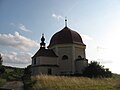
Chapel of the Visitation of Mary


Personalities
- Konstantin Biebl (1898–1951)
- Václav Votruba (1909–1990), physicist
Web links
Individual evidence
- ↑ http://www.uir.cz/obec/566713/Slavetin
- ↑ Český statistický úřad - The population of the Czech municipalities as of January 1, 2019 (PDF; 7.4 MiB)
- ↑ http://mapy.mzk.cz/mzk03/001/036/884/2619267255/
- ↑ Antonin Profous, Místní jména v Čechách dil III, Praha 1957
- ↑ http://www.uir.cz/casti-obce-obec/566713/Obec-Slavetin
- ↑ http://www.uir.cz/katastralni-uzemi-obec/566713/Obec-Slavetin