Staňkovice u Žatce
| Staňkovice | ||||
|---|---|---|---|---|
|
||||
| Basic data | ||||
| State : |
|
|||
| Region : | Ústecký kraj | |||
| District : | Louny | |||
| Area : | 1423.4772 ha | |||
| Geographic location : | 50 ° 21 ' N , 13 ° 34' E | |||
| Height: | 206 m nm | |||
| Residents : | 972 (Jan. 1, 2019) | |||
| Postal code : | 438 01 - 439 49 | |||
| License plate : | U | |||
| traffic | ||||
| Street: | Žatec - Raná | |||
| structure | ||||
| Status: | local community | |||
| Districts: | 4th | |||
| administration | ||||
| Mayor : | Jan Bartoň (as of 2013) | |||
| Address: | Postoloprtská 8 439 49 Staňkovice u Žatce |
|||
| Municipality number: | 543128 | |||
| Website : | www.stankovice.cz | |||
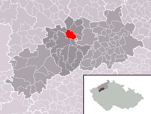
| Location of Staňkovice in the Louny district | ||||

|
||||
Staňkovice (German Stankowitz ) is a municipality in the Czech Republic . It is located three kilometers northeast of Žatec and belongs to the Okres Louny .
geography
Staňkovice is located on the left side of the confluence of the Hutná ( Saubach ) in the Eger in the North Bohemian Basin . The Bílá skála (266 m) and the Janský vrch ( Johannesberg , 286 m) rise to the northwest . To the north is the Triangle industrial area. The railway line Plzeň – Duchcov passes to the south, the nearest railway stations are Žatec and Tvršice.
Neighboring towns are Truzenice, Minice and Nehasice in the north, Zámeček, Tatinná, Bitozeves , Seletice and Seménkovice in the northeast, Postoloprty in the east, Selibice and Tvršice in the southeast, Bezděkov in the south, Žatec in the southwest, Velichov in the west and Žiželice in the northwest.
history
Archaeological finds show that the village, located on an old arm of the Eger, has been settled since the Stone Age . Probably in the 9th or 10th century, a small fortress and later the village of Chmelice were built on the site of today's castle on an Egerschleife. The village Staňkovice opposite Chmelice was first mentioned in writing in 1240 in a deed of ownership of the Strahov Monastery , from which it emerges that the abbot Adam Berhold Staňkovice had bought it in 1225 for 120 silver marks. From 1272 the order leased the village hereditary to Saaz citizens. During the Hussite Wars , the city of Saaz took possession of the goods. At the beginning of the 16th century, Chmelice became extinct for reasons not known in detail. Because of his participation in the uprising against the Habsburgs, Ferdinand I confiscated the town's possessions in 1547. The festival in Staňkovice was also mentioned. Until it was sold by Rudolf II in 1594, Staňkovice was then part of the Líčkov estate. After the Battle of White Mountain , Staňkovice was confiscated by Ferdinand II and acquired by the owners of the Líčkov estate, Jaroslav von Hasenburg and Esther Juliane Herzan von Harras, in the course of an exchange. In 1651 the village had 143 inhabitants. In the berní rula from 1654 34 properties are shown for Staňkovice, of which 18 were farmers, 10 were residents and six were gardeners. There were four large ponds around the place and wine had been grown on the slopes of the Egertal since 1378. By draining the Egers swamps, fertile soil was obtained that was suitable for growing hops and vegetables.
After the abolition of patrimonial Stankowitz / Staňkovice formed a municipality in the Saaz district in 1850 . The place had 355 inhabitants. In the years 1886, 1895 and 1901 Stankowitz was affected by the strong floods of the Saubach. In 1921 730 Germans, 93 Czechs and seven foreigners lived in the village. In 1930 Stankowitz had 825 inhabitants, 72 of them Czech.
After the Munich Agreement , the place was added to the German Reich in 1938 and belonged to the Saaz district until 1945 . In 1939 there were 764 people in the community. After the end of the Second World War, Staňkovice came back to Czechoslovakia. The German population was expelled and Wolhynientschechen settled.
By 1953 a housing estate was built for the soldiers' families from the Žatec military airfield. Staňkovice has belonged to Okres Louny since 1961, and in that year the place had the highest population in its history with 935 inhabitants. In 1975 it was incorporated into Žatec. The community has existed again since 1990. In 1996 the districts of Selibice and Tvršice were annexed by the town of Žatec to the municipality of Staňkovice.
On the former army airfield Žatec, the construction of the 365 hectare industrial area Triangle began in 2002, in which branches of the Japanese companies IPS Alpha Technology Europe and Hitachi Home Electronics were established. Under the name Průmyslová zóna Triangle it became part of the district of Velemyšleves and Staňkovice.
Community structure
The municipality Staňkovice consists of the districts Průmyslová zóna Triangle ( industrial and commercial area Triangle ), Selibice ( Sellowitz ), Staňkovice ( Stankowitz ) and Tvršice ( Twerschitz ). Basic settlement units are Selibice, Staňkovice and Tvršice. The municipality is divided into the cadastral districts of Selibice, Staňkovice u Žatce and Tvršice.
Attractions
- Church of St. Wenzel, the originally Gothic building, which can be traced back to 1272, received a new nave and a tower in 1606; in the 18th century it was redesigned in Baroque style
- Rectory, built in 1787
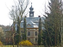
- Zámeček, the two-story late baroque chateau with a tower and several lanterns on the mansard roof, was built in the 19th century
- Chapel of Our Lady of Sorrows in Tvršice, in a dilapidated condition
- Chapel in Selibice
- Baroque farm in Selibice, from the 18th century
- Natural monument Bílá skála, the steep southern slope over the influence of the Hutná in the Eger Valley north-west of Staňkovice was protected in 1992 because of numerous species of heat-loving insects on an area of 6.86 hectares.
Sons and daughters of the church
- Josephine Schallowetz, married Baroness Ringhoffer (1822–1896), wife of a large industrialist, philanthropist and. pianist
- Miroslava Černá (* 1972), disabled athlete and archer, won medals at the 2008 Paralympics, the 2005 World Cup and the 2006 European Championship
Individual evidence
- ↑ http://www.uir.cz/obec/543128/Stankovice
- ↑ Český statistický úřad - The population of the Czech municipalities as of January 1, 2019 (PDF; 7.4 MiB)
- ↑ http://www.uir.cz/casti-obce-obec/543128/Obec-Stankovice
- ↑ http://www.uir.cz/zsj-obec/543128/Obec-Stankovice
- ↑ http://www.uir.cz/katastralni-uzemi-obec/543128/Obec-Stankovice


