Očihov
| Očihov | ||||
|---|---|---|---|---|
|
||||
| Basic data | ||||
| State : |
|
|||
| Region : | Ústecký kraj | |||
| District : | Louny | |||
| Area : | 1244.6156 ha | |||
| Geographic location : | 50 ° 12 ' N , 13 ° 28' E | |||
| Height: | 289 m nm | |||
| Residents : | 367 (Jan. 1, 2019) | |||
| Postal code : | 439 87 | |||
| License plate : | U | |||
| traffic | ||||
| Street: | Jesenice - Podbořany | |||
| structure | ||||
| Status: | local community | |||
| Districts: | 2 | |||
| administration | ||||
| Mayor : | Jana Kronďáková (status: 2013) | |||
| Address: | Očihov 7 439 87 Očihov |
|||
| Municipality number: | 566527 | |||
| Website : | www.ocihov.cz | |||
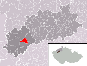
| Location of Očihov in the Louny district | ||||

|
||||
Očihov (German Groß Otschehau ) is a municipality in the Czech Republic . It is located five kilometers southeast of Podbořany and belongs to the Okres Louny .
geography
Očihov is located in the foothills of the Rakonitz hill country on the left bank of the Blšanka ( Goldbach ) between the confluences of the Očihovecký potok and Valovský potok. The Hůrka (437 m) rises to the east. The state road I / 27 runs from Jesenice to Žatec to the east of the village . Two lines of bunkers from the Czechoslovak Wall surround the place .
Neighboring towns are Letov and Blšany in the north, Stachov and Soběchleby in the northeast, Hradčany and Malá Černoc in the east, Očihovec in the southeast, Strojetice and Březnice in the south, Hřebíčkovský Mlýn, Kryry and Vroutek in the southwest, Valov in the west and Podbořany in the northwest.
history
The first written mention of Očihov was in 1289 as a property of the Vladiken of Přibyslav. There was a castle in Hradčany, which was probably the seat of this family who moved to Moravia in the 14th century . West of the village on the "na staré vsi" corridor was a much older settlement. In 1307 the Slawata acquired the Oczihov estate, consisting of the two villages Velký Očihov and Malý Očihov, and in 1330 it belonged to the possessions of the Prague bishop John IV of Dražice . During the reign of John of Luxembourg there was a revolt of the landed gentry in the area, which was put down by the king. Numerous villages were also burned down. After the Hussite Wars , the lords of Kolowrat , Seeberg, Lobkowicz and Gutstein took turns as owners. In 1546 the Velký Očihov was attached to the Rothschloß dominion and later to the Petersburg dominion . In the 16th century there was also a festival in Velký Očihov, which the Lords of Hrobschitz bought in 1544. To the west, numerous fish ponds were created as far as Wohlau.
After the Battle of White Mountain in 1623, Christoph von Hrobschitz's goods were confiscated and sold to Franz Clary da Riva . During the Thirty Years War the village was ravaged and the fortress was extinguished. Subsequently, the deserted area was repopulated with Germans. In the berní rula of 1654, 25 farms are designated for Očihov, four of which were deserted. In the second half of the 17th century the village became subject to the town of Podersam . The first village school can be found in Groß Otschehau in 1750. Teaching was in German.
After the abolition of patrimonial Groß Otschehau / Očihov formed a municipality in the Podersam district from 1850. To the west of the village, sandstone was extracted from the Wohlau sandstone quarries. At Groß Otschehau there was a ford through the Goldbach, which, because of its meander, was also called the broad brook . In 1872 the village was hit by a flood of the Goldbach, in which eight people drowned. After that, a wooden bridge was built over the stream, which was washed away several times during subsequent floods. In 1877 a new school building was inaugurated. In 1900 the community had 682 inhabitants. In 1921 the population consisted of 90% Germans. A Czech minority school was established in Podersam. However, the Czech workers at the Hardtmuth GmbH Budweis-Podersam pottery factory had to send their children to the German school in Groß Otschehau on the instructions of the management. In 1930 Groß Otschehau had 748 inhabitants.
After the Munich Agreement , the place was added to the German Empire and belonged to the Podersam district until 1945 . In 1939 there were 659 people living in the community. After the end of World War II, Očihov returned to Czechoslovakia and the German population was expelled .
Since 1961 Očihov belongs to the Okres Louny, at the same time Očihovec was incorporated. Between 1981 and 1990 Očihov was a district of Blšany .
There is a mineral water company in the municipality that bottles the Aqua Bohemica brand .
Community structure
The community Očihov consists of the districts Očihov ( Groß Otschehau ) and Očihovec ( Klein Otschehau ), which also form cadastral districts. The settlements Beraní Dvůr ( Mutton Farm ) and Hradčany also belong to Očihov .
Attractions
- Church of St. Martin, built after 1215
- Chapel in Očihovec
- Bunkers of the Czechoslovak Wall

