Libořice
| Libořice | ||||
|---|---|---|---|---|
|
||||
| Basic data | ||||
| State : |
|
|||
| Region : | Ústecký kraj | |||
| District : | Louny | |||
| Area : | 1033.6046 ha | |||
| Geographic location : | 50 ° 15 ' N , 13 ° 31' E | |||
| Height: | 259 m nm | |||
| Residents : | 349 (Jan 1, 2019) | |||
| Postal code : | 439 31 | |||
| License plate : | U | |||
| traffic | ||||
| Street: | Podbořany - Holedeč | |||
| structure | ||||
| Status: | local community | |||
| Districts: | 2 | |||
| administration | ||||
| Mayor : | Eva Vrábíková (as of 2013) | |||
| Address: | Libořice 30 438 01 Žatec 1 |
|||
| Municipality number: | 566381 | |||
| Website : | www.liborice.cz | |||
| Location of Libořice in the Louny district | ||||

|
||||
Libořice (German Liboritz , also Lieboritz ) is a municipality in the Czech Republic . It is located eight kilometers northeast of Podbořany and belongs to the Okres Louny .
geography
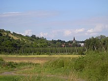
Libořice is located at the northwestern foot of the Džbán Mountains on the Blšanka ( Goldbach ). The Na Slatině (321 m) rises to the north and the Libořický kopec (342 m) to the west. To the south there are light bunker lines of the Czechoslovak Wall .
Neighboring towns are Milčeves in the north, Železná in the north-east, Nový Dvůr, Lhota and Sádek in the east, Želeč in the south-east, Soběchleby and Siřem in the south, Liběšovice in the south-west, Pšov and Sýrovice in the west and Kličín in the north-west.
history
The first written mention of the village was in 1333 as the property of the Roudnice nad Labem monastery . In 1338 the monastery in Libořice had a fortress built. In 1386 the Augustinians from Roudnica sold the property to Jan von Brloh. In 1404 Václav Valkoun von Solopysk bought the goods. Zikmund Řepanský of Řepany followed him in 1437. After numerous changes of ownership, Libořice passed to the lords of Kolowrat at the beginning of the 18th century . In 1718 Franz Josef Graf Schlick Libořice acquired from Maximilian Kolowrat-Libštejnský. He had the old fortress converted into an early baroque palace. In 1739 the Counts von Klebelsberg bought the property. After the castle had been repaired, Wenzel von Klebelsberg had a castle park laid out at the castle along the Goldbach. The execution was carried out from 1780 by the lordly horticulturist of Count Czernin Rudolf Födisch, who had designed the English landscape park in Schönhof .
After the abolition of patrimonial Lieboritz / Libořice formed a municipality in the Podersam district from 1850 . On February 4, 1871 by the Buštěhrad Railway route Prague-Chomutov privy to the north led by Schelesen in Goldbachtal. In the night from 25 to 26 May 1872 was Lieboritz after downpours of an overnight flash flood devastated the Goldbach and the palace gardens destroyed. In the same year, the Counts Klebelsberg sold the castle and estate to the Michelober brewery owner Anton Dreher . In 1930 the community had 729 inhabitants.
After the Munich Agreement , the place was added to the German Reich in 1938 and belonged to the Podersam district until 1945 . The Czech population left the village because of the disadvantages that began and moved across the nearby imperial border into Czechoslovakia. In 1939 there were 598 people in the community. After the end of World War II, Libořice came back to Czechoslovakia and the German population was expelled .
At the beginning of 1961 the incorporation of Železná took place, at the same time the place was assigned to the Okres Louny . Between 1981 and 1990 Libořice was incorporated into Měcholupy .
Community structure
The municipality Libořice consists of the districts Libořice ( Liboritz ) and Železná ( Schelesen ), which also form cadastral districts.
Attractions
- Libořice Castle, the three-wing building was built in 1737 for Franz Josef Schlick at an old fortress. In 1924 the castle was redesigned.
- Baroque Church of the Assumption of Mary, built in 1716 in place of a previous building from the 14th century
- Rectory built in the second half of the 18th century
- Chapel on the road to Milčeves
- Menhir "Zlaťák", the 3 m high quartzite block was erected in 2009 in Železná at the ford through the Blšanka. It used to be in a field and then in the 1980s it was dredged and thrown into the Želečský potok gorge.
- Railway bridge over the Blšanka near Železná, built in the 1870s, technical monument
- Chapel in Železná
Individual evidence
- ↑ http://www.uir.cz/obec/566381/Liborice
- ↑ Český statistický úřad - The population of the Czech municipalities as of January 1, 2019 (PDF; 7.4 MiB)
- ↑ http://www.uir.cz/casti-obce-obec/566381/Obec-Liborice
- ↑ http://www.uir.cz/katastralni-uzemi-obec/566381/Obec-Liborice
Web links


