Blažim
| Blažim | ||||
|---|---|---|---|---|
|
||||
| Basic data | ||||
| State : |
|
|||
| Region : | Ústecký kraj | |||
| District : | Louny | |||
| Area : | 963,304 hectares | |||
| Geographic location : | 50 ° 24 ' N , 13 ° 38' E | |||
| Height: | 261 m nm | |||
| Residents : | 265 (Jan. 1, 2019) | |||
| Postal code : | 439 42 | |||
| License plate : | U | |||
| traffic | ||||
| Street: | Havraň - Bitozeves | |||
| structure | ||||
| Status: | local community | |||
| Districts: | 1 | |||
| administration | ||||
| Mayor : | Oldřich Sodomka (as of 2020) | |||
| Address: | Blažim 107 440 01 Louny 1 |
|||
| Municipality number: | 566012 | |||
| Website : | www.blazim.cz | |||
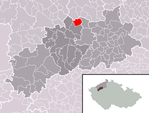
| Location of Blažim in the Louny district | ||||

|
||||
Blažim (German Ploscha ) is a municipality in the Czech Republic . It is located eleven kilometers northeast of Žatec and belongs to the Okres Louny .
geography
Blažim is located in the North Bohemian basin in the source basin of the creek Blažimský Potok, of the village of anger feeds a pond. To the north rises the Zvonice (275 m), in the east the Vyhlídka ( Baba , 285 m) and in the west the Uhelný vrch ( Kohlberg , 313 m). In the northwest on Havraňer Flur lies the Joseph industrial area and to the northeast is the remaining pit of an open-cast lignite mine, where the village of Třískolupy previously stood, and behind it the Počerady power station.
Neighboring towns are Koporeč and Polerady in the north, Počerady in the northeast, Břvany in the east, Výškov and Vidovle in the southeast, Bitozeves and Tatinná in the south, Nehasice, Minice and Truzenice in the southwest, Velemyšleves , Zálezly, Škrle and Voděrady, Saběnice and in the west as well as Suěnice und Moravěves in the northwest.
history
Sblažim was first mentioned in writing in 1183 as a property of the Order of St. John . On the hill next to the church there was a fortress that has been documented as the seat of the Litolt of Moravěves since 1390. During the Hussite Wars , the town of Louny took possession of the goods in Dlažim . In 1454 Ladislaus Postumus moved in the fortress and the village and gave them to Jaroslav von Vřesovice. After his death, Jindřich Dlažimský von Vřesovice followed in 1467 and from 1533 the captain of the Saaz District, Jan Dlažimský von Vřesovice, as the owner. The lords of Vřesovice held Blažim until it was sold to Paul Michna von Vacínov in 1629. Michna gave the goods in Blažim to the Postelberg estate . In 1671 Georg Ludwig von Sinzendorf acquired Postelberg with all the associated villages. At that time the old fortress was already in ruins. When the rulership was sold to Ferdinand zu Schwarzenberg , a burnt down sheep farm was next to the village - and the festivals were held for the last time. Then the ruinous building was converted into a farm yard. During the plum rumble , Prussian hussars occupied Ploscha, Wischkowa and Potscherad on August 27, 1778 . Since the middle of the 19th century, lignite pits were operated in the vicinity of Ploscha.
After the abolition of patrimonial Ploscha / Blažím formed a political municipality in the Postelberg district from 1850 and, after its abolition, in the Saaz district . In 1930 the community had 554 inhabitants.
After the Munich Agreement , Ploscha was added to the German Reich and belonged to the Saaz district until 1945 . In 1939 there were 426 people living in the village. After the end of World War II, Blažím came back to Czechoslovakia and the German population was expelled .
Blažím has been part of the Okres Louny since 1961 . At the end of the 1960s, a brown coal field was developed between Blažím, Polerady and Počerady. The village of Třískolupy located on it was devastated in 1973 because of the open pit and a power plant was built between Polerady and Počerady. Between 1981 and 1990 the village was incorporated into Výškov . Due to the location at the opencast mine, the number of inhabitants fell to 124 by 1989. Since 1990 the community began to remove the neglect from the time of communist rule and new single-family houses were built.
Community structure
No districts are designated for the municipality of Blažim.
Attractions
- baroque church of St. Prokop, in the center of the village by the pond, built from 1778 to 1781 according to plans by J. Jakobi
- Blažim farm, on an elevated place north of the pond, in the eastern part of the fortress walls have been preserved
- Rectory, built in 1710/11 according to plans by Paul Ignaz Bayer
- Statue of St. John of Nepomuk, at the pond


