Okres Chomutov
| Okres Chomutov | |
|---|---|
| Kraj | Ústecký kraj |
| surface | 935.27 km² |
|
Inhabitants • Population density |
124,751 ( January 1, 2019 ) 134 inhabitants / km² |
|
Municipalities • of which cities • of which Městyse |
44 8 0 |
| LAU 1 | CZ0422 |
|
Vehicle registration number (issued until 2001) |
CV |

|
|
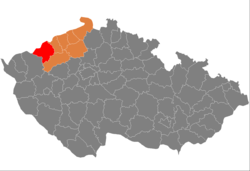
The Okres Chomutov (German district Komotau , during the German occupation 1938–1945 district Komotau ) was a regional authority in Ústecký kraj (Aussig region) in the Czech Republic . The Okresy were roughly comparable to the counties in Germany and were dissolved on December 31, 2002 .
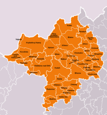
Okres Chomutov spreads in the southwestern part of the Ústecký kraj (Czech Republic). 124,751 inhabitants (as of January 1, 2019) live on 935 km² in eight cities and 36 municipalities with 173 districts.
The district can be divided into four regions, each of which has special characteristics:
- Ore Mountains (Krušné hory), which occupy 41% of the area and represent the oldest geological formation. This area plays an important role in the climatic area and as a water reservoir. The Preßnitz dam , which was built in 1974, provides drinking water
- Mostecký úval basin with rich deposits of brown coal
- Saaz Basin (Žatecká pánev), an agriculturally productive area
- Duppau Mountains (Doupovské hory)
The forests take up about 30% of the area and are currently being reforested after the great forest dieback in the 1970s.
The Chomutov district was the industrial center of heavy industry, power generation, steel processing and mining. Restructuring and closings over the last decade made it less important and at the same time increased the unemployment rate to 17%.
cities and communes
(Cities are marked in bold)
- Bílence ( Bielenz )
- Blatno ( plates )
- Boleboř ( Göttersdorf )
- Březno ( Priesen )
- Černovice ( Tschernowitz )
- Domašín ( Tomichan )
- Droužkovice ( Trauschkowitz )
- Hora Svatého Šebestiána ( Sebastiansberg )
- Hrušovany ( Hruschowan )
- Chbany ( Kwon )
- Chomutov ( Komotau )
- Jirkov ( Görkau )
- Kadaň ( Kaaden )
- Kalek ( Kallich )
- Klášterec nad Ohří ( Klösterle on the Eger )
- Kovářská ( Forge Hill )
- Kryštofovy Hamry ( Christophhammer )
- Křimov ( Krima )
- Libědice ( Libotitz )
- Loučná pod Klínovcem ( Bohemian Wiesenthal )
- Málkov ( Malkau )
- Mašťov ( Maschau )
- Měděnec ( Copper Mountain )
- Místo ( square )
- Nezabylice ( Neosablitz )
- Okounov ( Okenau )
- Otvice ( Udwitz )
- Perštejn ( Pürstein )
- Pesvice ( Pößwitz )
- Pětipsy ( five dogs )
- Račetice ( Ratschitz )
- Radonice ( Radonitz )
- Rokle ( Rachel )
- Spořice ( Sporitz )
- Strupčice ( Trupschitz )
- Údlice ( Eidlitz )
- Vejprty ( Weipert )
- Veliká Ves ( Michelsdorf )
- Vilémov ( Willomitz )
- Vrskmaň ( Wurzmes )
- Všehrdy ( Tschern )
- Všestudy ( Schößl )
- Výsluní ( Sun Mountain )
- Vysoká Pec ( Hohenofen )
Historic buildings and landmarks
Castles and palaces, ruins
- Bílence : ruinous baroque castle Bílence ( Bielenz ).
- Blatno : Blatno hunting lodge ( slabs ).
- Blatno : ground monument Burg Najstejn ( Neustein ), small residues, and mounds cistern in Blatno / TELS / Orasín, accessible only by means of or Orasín.
- Chomutov : Remainder of the former castle with castle church (St. Katharinenkirche, early Gothic around 1281) (today town hall with exhibitions in the church) of the Teutonic Knights Order on the market square.
- Chomutov : Hausberk Castle ground monument on the western edge of the Chomutovka valley north of Chomutov.
- Chomutov : soil monument Castle Hill ( Hradiste ) Chomutov, northwest of Chomutov
- Jirkov Castle Cerveny Hradek ( Roth House ), Castle and Military Museum.
- Kadaň : Kadaň Castle ( Kaaden ).
- Kalek : Baroque hunting lodge Kalek ( Kallich ).
- Klášterec nad Ohří : Klášterec nad Ohří chateau - neo-Gothic chateau, chateau museum, chateau park.
- Klášterec nad Ohří : Šumburk castle ruins ( Schönburg or Neuschönburg ) on the mountain Šumna to the west.
- Lestkov: Egerberk castle ruins , Lestkov near Klášterec nad Ohří .
- Lestkov: Klasterec nad Ohri / OT Lestkov, ruined castle Funkštejn ( Funkenstein ) east of Lestkov ( Leskau ) and southeast of Rašovice ( Roschwitz ) on a ridge, minimal residues (archaeological monument).
- Libědice : Baroque Libědice chateau , threatened with decay.
- Mašťov : Baroque castle Mašťov ( Maschau ).
- Místo : castle ruins Hasištejn ( Hassenstein ), exhibitions, restaurant, mountable keep, Goethe monument .
- Oslo Vice : remains of the castle Klejnštejn ( small stone ), vrch on Humnický, Oslo Vice at Okounov (archaeological monument).
- Perštejn : Perštejn castle ruins ( Pürstein ), Perštejn near Klösterle on the Eger.
- Pětipsy : Pětipsy castle ruins ( five dogs ).
- Rokle : Castle Rokle ( Rachel ).
- Rašovice: Klášterec nad Ohří / district Rašovice ( Roschwitz ) with castle ruins Felixburk ( Felixburg ) (small remains).
- Údlice : Baroque chateau Údlice ( Eidlitz ).
- Veliká Ves : Neo-Renaissance castle Veliká Ves ( Micheldorf ).
- Vernéřov near Klášterec nad Ohří : Vernéřov castle ruins ( Wernsdorf ), small remains.
- Vilémov : Vilémov Castle ( Willomitz ), private property.
- Vintířov: Old Vintířov Castle (Renaissance Winteritz Castle , ruined) and New Vintířov Castle (Baroque Winteritz Castle ), near Radonice u Kadaně ( Radonitz ).
- Vysočany: Baroque Vysočany chateau near Hrušovany u Chomutova , now a hotel.
- VYSOKÁ PEC : ruins of the castle Nový Žeberk ( New Seeberg ), on the Zámecký vrch in Pyšná, low residues.
- Vysoká Pec u Jirkova : ruins of the Žeberk / Starý Žeberk castle ( Old Seeberg or Seeberg ), north of the village, little remains.
Museums
- Chomutov : Chomutov District Museum (Oblastní muzeum v Chomutově), in the town of Chomutov.
- Chomutov : Remnants of the former castle with castle church (today museum and town hall) of the Teutonic Knights on the market square.
- Chomutov : Railway exhibition in Chomutov, part of the National Technical Museum in Prague .
- Jirkov : Castle Cerveny Hradek ( Roth House ), Castle and Military Museum.
- Kadaň : Municipal Museum.
- Klasterec nad Ohri : Klášterec nad Ohří ( Klösterle an der Eger ) - Neo-Gothic castle, Castle Museum / Porcelain Museum , Castle Park.
- Kovářská : Museum of the Battle of the Ore Mountains in 1944 .
- Křimov : Railway Museum .
- Měděnec : Local History Museum (small mining museum).
Others
- Blatno : ruinous church "Archangel Michael" (under restoration) and 250 year old Swedish linden tree.
- Boleboř : Baroque Boleboř Chapel ( Göttersdorf ).
- Chomutov : Jesuit area Chomutov near the market square directly on the Chomutovka river .
- Chomutov : "Bezručovo údolí" nature reserve north of Chomutov on the Chomutovka river .
- Domašín : medieval agate mine near Domašín, mining monument.
- Gabrielina Huť : Desolation of the Gabriellahütten industrial estate with ruins near Kalek .
- Hora Svaté Kateřiny : Nikolaistollen ( Mikulášská štola ) visitor mine in Hora Svaté Kateřiny ( Katharinaberg ).
- Jirkov : Jirkov town cellar / caves / ice cellar, visits possible by appointment.
- Kadaň : Franciscan monastery of Kadaň .
- Kadaň : Kaaden old town with market square (national monument protection zone).
- Klášterec nad Ohří : Well house of the Eugenienquelle.
- Klášterec nad Ohří / Wüstung Mikulovice ( Niklasdorf ) west of Klösterle: Village church of St. Nicholas (under restoration) and parts of the cemetery preserved. A statue of St. Nepomuk from Niklasdorf (and other statues) are said to have been moved to Klösterle.
- Kotlina : Partial desertification of Kotlina ( Köstelwald ), restored "St. Anna" chapel (village church).
- Kovářská : Schmiedeberg lime works (part of the world cultural heritage of the Erzgebirge mining region) and ruins of the charcoal store of an old ironworks. Natural monument "Schwedenlinde" on the road to Černý Potok ( Pleil ).
- Křimov : baroque rectory.
- Květnov : Květnov pilgrimage site.
-
Měděnec : two show mines:
- "Promised Land Stolln" (Štola Země Zaslíbená) and
- Mariahilfstolln (Štola Marie Pomocná), both on the Kupferhübel mountain (part of the world cultural heritage of the Erzgebirge mining region).
- Otvice : Otvice water tower ( Udwitz ).
- Various locations: Bunker chain (s), parts of the Czechoslovak Wall on the southern slopes of the Ore Mountains in a ring north around Chomutov , as well as along the Eger River.
- Volyně : Partly deserted Volyně ( Wöhlau ) near Výsluní ( Sonnenberg ) with a restored village church "St. Peter and Paul".
- Výsluní : Neo-Gothic hall church of St. Wenceslas Church in Výsluní ( Sonnenberg ).
Web links
- Chomutov and its surroundings, official website, www.kr-ustecky.cz
- Český statistický úřad (Czech Statistical Office), Ústí nad Labem, www.ustinadlabem.czso.cz
Individual evidence
- ↑ http://www.uir.cz/okres/3503/Chomutov
- ↑ Český statistický úřad - The population of the Czech regions and counties as of January 1, 2019 (XLSX)
Coordinates: 50 ° 26 ' N , 13 ° 18' E
