Remelturm
|
Remelturm
|
||
|---|---|---|
| Basic data | ||
| Place: | Kleinlützel | |
| Canton: | Solothurn | |
| Country: | Switzerland | |
| Altitude : | 832 m | |
| Coordinates: 47 ° 26 '43.3 " N , 7 ° 25' 12" E ; CH1903: five hundred and ninety-eight thousand five hundred and ninety-five / 254951 | ||
| Use: | Observation tower | |
| Accessibility: | Observation tower open to the public | |
| Tower data | ||
| Construction time : | 1901 | |
| Building material : | concrete | |
| Total height : | 8.00 m | |
| Position map | ||
|
|
||
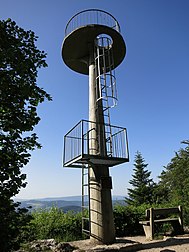
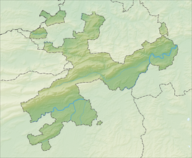
The Remelturm (also: Rämelturm ) is an eight meter high tower at 832 meters above sea level . in the area of the Swiss municipality of Kleinlützel ( Canton Solothurn ) two meters from the border with the French Wolschwiller ( Département Haut-Rhin ).
It was created in 1901 on the border between Switzerland and the then German Empire . In 1830, the signal point for the Swiss national survey was established at the same point. During the First World War between 1914 and 1918, the Remel Tower was used as a guard post. The area was a strategically central area in both World War I and World War II, as attacks by the opposing war opponents German Reich and France, with possible violation of Swiss territory, were expected there, especially at the beginning of the war.
The tower was renovated in 2005 by the Kleinlützel community , with construction apprentices from Solothurn helping. In addition, the Friends of the Remelturm association , the federal government, cantons, municipalities and donors supported the project.
For safety reasons, only a maximum of 4 people are allowed on the viewing platform. This is reached via 22 ladder steps.
A narrow mountain road leads from Kleinlützel to Chremelsmatte . From there you can reach the observation tower via hiking trails in around 15 minutes.


