Renier Point
| Renier Point | ||
 Lyulin Peak (double peaks ) and Renier Point (right) |
||
| Geographical location | ||
|
|
||
| Coordinates | 62 ° 37 ′ S , 59 ° 48 ′ W | |
| location | Livingston Island ( South Shetland Islands ) | |
| Waters | Bransfield Street | |
| Waters 2 | McFarlane Strait | |
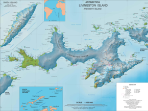
 Map of Livingston Island with Renier Point (right) |
||
The Renier Point is a narrow and up to 208 m high point of land , which represents the eastern extension of Livingston Island in the archipelago of the South Shetland Islands . Together with Ephraim Bluff on the opposite island of Greenwich Island, it marks the southeast entrance to McFarlane Strait .
The headland's name has been established in the waters around the South Shetland Islands since at least 1821 by the first seal hunters. The naming background is not known. The name Pin Point ( English for needlepoint ), the 1,935 participants of the British Discovery Investigations forgave, was rejected in favor of Erstbenennung.
Web links
- Renier Point in the Geographic Names Information System of the United States Geological Survey (English)
- Renier Point on geographic.org (English)
