Gunnuhver
| Gunnuhver | ||
|---|---|---|
|
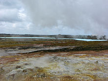
Gunnuhver Aug 2008 |
||
| height | 40 m | |
| location | Iceland | |
| Coordinates | 63 ° 49 '10 " N , 22 ° 41' 6" W | |
|
|
||
| Type | Crevasse volcano | |
| Last eruption | 1926 (submarine off Reykjanes) | |
| particularities | partially submarine volcanic system; Geothermal power plant on the central volcano | |
|
Gunnuhvergebiet with power station Suðurnes (left) |
||
The Gunnuhver volcano is located in southwest Iceland , west of the fishing village of Grindavík . This is the central high temperature area of the Reykjanes volcanic system , which is located on the peninsula of the same name .
The Reykjanes volcanic system
The high temperature area of Gunnuhver
Temperatures under the springs are over 300 ° C, making it one of the hottest spots in southwest Iceland, literally.
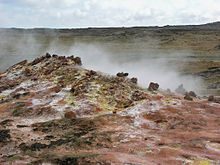
In the high temperature area there are mud springs and fumaroles . The water to be observed is rainwater, without which the area would be dry. On the other hand, there is pure salty seawater in crevices and caves under the high temperature area.
Volcanic activity continues in this and other volcanic systems on the ocean floor, i.e. H. on the part of the Mid-Atlantic Ridge that rises here towards Iceland and is called the Reykjanes Ridge . The last detectable eruption in the Reykjanes volcanic system took place at submarine eruption sites on the Reykjanes Ridge southeast of Eldey in 1926.
Recent developments in the high temperature area
The volcano has become more active since 2006. An access road had to be closed in 2008 because a new source of clay had come into action in the middle of the way. In addition, Gunnuhver sometimes has small slag outbreaks and hurls hot bits of clay 2 to 4 m high into the air. Such changes and outbreaks were also observed at the Gunnuhver in 1905 and 1967.
There were also explosions in the spring, so that the area was temporarily cordoned off. Since the source is unpredictable and you don't know how far the very hot bits of clay will be thrown, it is highly recommended to keep yourself at a safe distance.
In addition, similar activities at a mud source on Kleifarvatn have already led to an explosion in which glowing bits of clay flew several hundred meters through the air (see Krýsuvík ).
The development of a crater in the area has been observed since 2008 , as can be clearly seen in the images from August 2008.
After being closed for several years, the area has been partially accessible again since summer 2010.
Suðurnes geothermal power plant
The energy of the volcanic system is used in a geothermal power plant, the Suðurnes power plant. In addition, the salt water that has penetrated caves and heated by the volcano is used in a factory.
The series of craters of the Eldvbod also belongs to the Reykjanesystem. There is another high-temperature area that is also used by the Suðurnes power plant.
Naming
The name of the high-temperature area Gunnuhver is related to the legend of a ghost named Gunna (actually Guðrún Önundardóttir). This ghost was haunted here and played tricks on people like z. B. hides their cattle. Finally, the pastor, Eiríkur Magnússon, succeeded in capturing the spirit in the hot spring, which was then given the name Gunna.
See also
Web links
Photos and videos
- Older video Gunnuhver in action, July 2007
- Photo: Condition of the former roadway in April 2008
- New sludge source at the Gunnuhver in June 2008, picture and isl. comment
Scientific contributions
- Reykjanes in the Global Volcanism Program of the Smithsonian Institution (English)
- R. Sigbjörnsson, SM Higgins, S. Ólafsson, B. Halldórsson, J. Th. Snæbjörnsson: Comparative Study of Uniform Hazard Spectra Derived using Ground Motion Estimation Models: A Case Study. (PDF; 835 kB). The 14th World Conference on Earthquake Engineering October 12–17, 2008, Beijing, China (English)
- M. Keiding et al. a .: Plate boundary deformation and man-made subsidence around geothermal fields on the Reykjanes peninsula, Iceland, doi : 10.1016 / j.jvolgeores.2010.04.011 . (English)
Further
- Webpage of the place Grindavík (Icelandic)
- Varað við Gunnuhver. Vísir , March 4, 2008 (Gunnuhver: Risk of slag eruption, March 2008) (Icelandic)
- Leirgos í Gunnuhver. , Vísir , March 3, 2008 (slag eruption on the Gunnuhver, March 2008, isl. M. Picture)
Individual evidence
- ↑ http://www.volcano.si.edu/volcano.cfm?vn=371020&vtab=Eruptions Access: February 20, 2011 (English)
- ↑ http://www.visir.is/article/20080303/FRETTIR01/80303082 Website of the newspaper Vísir, March 3, 2008, isl.
- ↑ http://landogsaga.is/section.php?id=1599&id_art=1618 ; Accessed February 20, 2011 (Icelandic)
- ↑ http://www.vf.is/Frettir/36518/default.aspx ; Internet newspaper VF, June 20, 2008, isl .; Accessed March 11, 2010 (Icelandic)
- ↑ cf. Web links
- ↑ cf. http://www.vf.is/Frettir/45001/default.aspx Accessed: February 20, 2011, isl.
- ↑ Grindavík website; Accessed March 11, 2010 (Icelandic)


