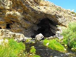
Rick's Spring
| Rick's Spring | |||
|---|---|---|---|
 Rick's Spring |
|||
| location | |||
| Country or region | Cache County , Utah ( United States ) | ||
| Coordinates | 41 ° 50 ′ 24 " N , 111 ° 35 ′ 20" W. | ||
|
|||
| geology | |||
| Mountains | Wasatch Range ( Rocky Mountains ) | ||
| Source type | Karst spring | ||
| Exit type | Spring cave | ||
| rock | limestone | ||
| Hydrology | |||
| River system | Bear River | ||
| Receiving waters | Logan River → Little Bear River → Bear River → Great Salt Lake | ||
Coordinates: 41 ° 50 ′ 24 " N , 111 ° 35 ′ 20" W.
Ricks Spring (German: Ricks Quelle) is a karst spring in the state of Utah in the United States .
geography
The source is located in Cache County , about 15 miles northeast of Logan and 20 miles southwest of Garden City as the crow flies . It is located in the Wasatch-Cache National Forest in the Wasatch range (part of the Rocky Mountains ) on the right bank of the Logan River , which flows through the Logan Canyon there . Highway 89 runs through the valley . The water from the large cave portal flows into the Logan River after about 50 m. Ricks Spring is located in a drainless catchment area , the Great Basin .
Hydrology
In the 1950s, hydrogeologists noticed a connection between the flow behavior of the Logan River and the source. The theory of a connection between the two emerged. In 1972, a harsh winter froze the river in places, causing the water to build up upstream. The discharge in Ricks Spring increased and only subsided when the level of the Logan River sank again. This confirms the connection between the river and the karst spring. During dyeing tests in the Logan River, traces of the test salts were later found in the water of the spring.
Later, through further dyeing experiments, it was found that the Logan River does not feed Rick's Spring alone. The water of several smaller streams within a radius of eight kilometers and in some cases up to 800 meters higher, also emerges again in Ricks Spring. There is also an underground connection between Tony Grove Lake and the karst spring.
geology
Ricks Spring rises from a mighty cave portal consisting of layers of sediment in the rock. The rock was made to fold by pressure and earthquakes, so that it broke open at weak points and crevices formed. Over time it eroded and water penetrated through these points into the karstified limestone . An underground river was created, which absorbs water from the surrounding streams and lakes and emerges at the source.
There are two caves in Ricks Spring. The upper water cave extends about eight meters into the rock. The second cave is an extensive network of wet and dry passages that can only be reached by cave diving . Since 2009 it has been explored up to approximately 660 m.
history
Thomas Edwin Ricks settled in the nearby Cache Valley in 1859. Logan Canyon was an area that was rich in timber and other resources for the nearby settlements. Rick's explorations of the canyon are among the first to document the area. In 1899, Ricks and others began building a road to the Bear Lake Valley . The first section of the way to Ricks Spring was completed before winter. Within a decade, the area became a popular destination. The road is now part of the Logan Canyon Scenic Byway, part of Highway 89.
See also
Web links
Individual evidence
- ↑ Google Earth
- ↑ Logan Canyon Scenic Byways: ... Green Dye, Utah: State of Utah
- ↑ Logan Canyon Scenic Byways: Folds and Fractures, Utah: State of Utah
- ↑ Randy Thornton: Exploring Virgin Cave in Ricks Spring Utah. Cave Divers Forum, 2009. (English)
- ↑ Logan Canyon Scenic Byways: What's in a Name, Utah: State of Utah
