from Wikipedia, the free encyclopedia
|
Riebnes
|
|
|
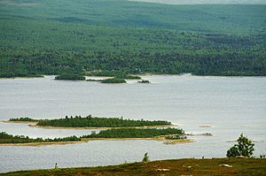
Riebnes with Vuonatjviken
|
| Geographical location
|
Lapland , Sweden
|
| Drain
|
Riebnesströmmen
|
| Location close to the shore
|
Arjeplog
|
| Data
|
|
Coordinates
|
66 ° 30 ′ N , 17 ° 8 ′ E Coordinates: 66 ° 30 ′ N , 17 ° 8 ′ E66.504166666667 17.134722222222 510
|
|
|
|
Altitude above sea level
|
510 m above sea level
|
| surface
|
63.3 km²
|
| length
|
30 km
|
| width
|
4 km
|
| scope
|
84.7 km
|
| Maximum depth
|
42 m
|
Riebnes is a lake in the municipality of Arjeplog in Norrbotten County in the Swedish historical province of Lapland . It is located at an altitude of 510 m above sea level. and is 63.3 km² in size and drains over the Riebnesströmmen to the Hornavan and thus to the Skellefte älv . The distance to the sea is 311 km. The lake, which is not accessible by a road, is crossed by the Kungsleden hiking trail at Vuonatjviken .
Individual evidence
-
↑ SE736453-156767
-
↑ a b Sverige vägatlas, Norstedts, Stockholm, 2014, ISBN 978-91-1305683-8
-
↑ Sjödjup och sjövolym (712.6 kB; PDF) , Svenskt vattenarkiv (SVAR), Sveriges meteorologiska och hydrologiska institut (Swedish)


