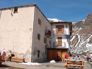
Rifugio Celery
| Rifugio Celery | ||
|---|---|---|
| location | Next to the Alpe Sellereis, below the Monte Orsiera ; Piedmont , Italy | |
| Mountain range | Cottian Alps | |
| Geographical location: | 45 ° 2 '51 " N , 7 ° 7' 12" E | |
| Altitude | 2030 m slm | |
|
|
||
| owner | Regione Piemonte | |
| Usual opening times | all year round | |
| accommodation | 40 beds, 0 camps | |
The Rifugio Selleries is an alpine refuge at 2030 m in Piedmont and is located in the Parco naturale Orsiera - Rocciavrè , a nature park in the Cottian Alps next to the Alpe Sellereis below the Monte Orsiera .
Approach
From Villaretto Chisone via Borgata Selleiraut you can climb to the hut in two and a half to three hours from the Chisonetal . Alternatively, you can drive to the hut in an all-terrain car.
Tours
The Monte Orsiera ( 2890 m ) can be reached in two and a half to three hours. The Punta Cristalliera ( 2801 m ) is achieved on the normal path in two and a half hours. The hut is also a base on a multi-day hike through the nature park, the Giro dell'Ossiera .
Literature and maps
- Iris Kürschner: Piedmont North - from Monte Rosa to Monviso; 44 selected hikes and treks. Rother hiking guide, Bergverlag Rother, Munich 2009, ISBN 978-3-7633-4360-7 .
Individual evidence
- ^ Hut website (Italian, accessed April 14, 2016)
- ^ Iris Kürschner: Piedmont North: from Monte Rosa to Monviso; 44 selected hikes and treks. Rother hiking guide, Bergverlag Rother , Munich 2009, ISBN 978-3-7633-4360-7 .

