Red (Stuttgart)
|
Rot district of Stuttgart |
|
|---|---|
| Coordinates | 48 ° 50 '2 " N , 9 ° 11' 34" E |
| surface | 1.558 km² |
| Residents | 10,518 (May 31, 2020) |
| Population density | 6751 inhabitants / km² |
| Post Code | 70437 |
| prefix | 0711 |
| Borough | Zuffenhausen |
| Source: Data Compass Stuttgart (PDF) | |

Rot is a district on the northern edge of the Baden-Württemberg state capital Stuttgart . It belongs to the city district of Zuffenhausen , is 155.8 hectares in size and lies between Zuffenhausen, Freiberg and Zazenhausen .
history
The Stuttgart district of Rot was settled in the post-war years in order to provide refugees and returnees with fast and inexpensive living space. This history of origin still shapes the district and the people in red today.
The first development of the Rot district began in 1928 in the former shell limestone quarry with the field name Malberg. Because of the housing shortage in the city of Zuffenhausen, four buildings (Pliensäckerstraße 2 to 8) were built there after the First World War . Further permanent and temporary buildings were erected by 1935, three of which are still there (Pliensäckerstraße 18 to 22).
From 1938 to 1940 the Rotweg settlement with 101 homes and a kindergarten was built east of the Malberg settlement.
In 1949, after the Second World War , around 35% of all apartments in Stuttgart were destroyed, and previous agricultural areas were used for residential development. So by 1960, new living space for 15,000 people in red was built, mostly in the four to five-story apartment blocks that are still typical for red today.
The district designation "red" was decided on July 27, 1961 in the city council of Stuttgart.
Due to the lack of building sites and small apartment blocks in the apartment blocks, the social structure was unbalanced. In 2003, red was included in the federal-state program " Districts with Special Development Needs - The Social City ".
In October 2013, the 3rd Red Autumn Festival celebrated the completion of many successful projects in the Rot district. Since then, the Stuttgart-Rot citizens' association has taken on additional tasks .
Infrastructure
In terms of education, Rot has a primary and secondary school with a Werkrealschule, a secondary school, the Ferdinand-Porsche-Gymnasium and a school for children with visual impairments. There are also numerous kindergartens and day care centers.
For daily needs there are supermarkets, bakeries, a flower shop, an optician, a kiosk, a beverage market, a jeweler, restaurants and snack bars. The service sector includes doctors, pharmacies, hairdressers, insurance companies, craftsmen, driving schools and banks. The Bürgerhaus, which opened in 2007, provides an event room. Since September 2014 there has also been a weekly weekly market on Hans-Scharoun-Platz.
Attractions
- High-rise buildings Romeo and Juliet (1954–1959) by Hans Scharoun
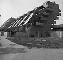
- Terrace house on Tapachstrasse, built 1969–1971 by Peter Faller and Hermann Schröder
- The community center was opened on May 12 of 2007. It was created from the main building of the Evangelical Community Center as part of the funding program “Districts with Special Development Needs - The Social City”.
traffic
The U7 tram and the 52 and N4 buses of the Stuttgart trams (SSB) go through red .
Web links
Individual evidence
- ^ Spatial structure of the state capital Stuttgart
- ↑ Data compass city districts Stuttgart 2007/2008 - city district profile 23 Zuffenhausen (PDF file; 1.75 MB)
- ↑ Announcement in Official Gazette No. 39 of September 28, 1961; Mitt. 1961 No. 21 p. 226
- ↑ Delimitation plan Zuffenhausen 6 -Rot- (PDF - 1.949 KB)
- ↑ https://s-rot.de
- ↑ Brochure - Bürgerhaus Rot (PDF - 5,440 KB)


