Routan Islands
| Routan Islands | ||
|---|---|---|
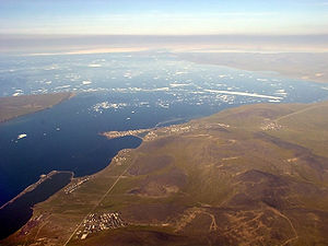
| Bolshoi Routan on the left in the aerial view of the city of Pewek | ||
| Waters | East Siberian Sea | |
| Geographical location | 69 ° 45 ′ N , 170 ° 8 ′ E | |
|
|
||
| Number of islands | 2 | |
| Main island | Bolshoi Routan | |
| Total land area | 31 km² | |
| Residents | uninhabited | |
| Map of the archipelago | ||
The two Routan Islands (formerly also Arautan, Russian Острова Роутан ) are located in the Tschaun Bay of the East Siberian Sea off the north coast of Siberia . The archipelago is separated from the city of Pewek by an approximately 4.7 km wide sound . It includes the 9.5 km long and 4.5 km wide island of Bolshoi Routan (area 30 km²) and the smaller 1.3 km long and 1 km wide island of Malyj Routan . The islands belong to the Chaunsky Rajon of the Chukchi Autonomous Okrug of Russia .
The islands first became known to Europeans in 1821 when Ferdinand von Wrangel mapped the coast of Eastern Siberia.
There is a small research station on Bolshoy Routan , the Bolshoy Routan Hut .
literature
- Prostar Sailing Directions 2005 North Coast of Russia Enroute . National Geospatial-intelligence Agency, ProStar Publications, Annapolis 2005, p. 140. ISBN 978-1-57785-756-3 (English)
Individual evidence
- ↑ French Polar Team: Arctic Station List, Vol. 2 ( page no longer available , search in web archives ) Info: The link was automatically marked as defective. Please check the link according to the instructions and then remove this notice. ( MS Excel ; 496 kB)


