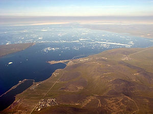
Tschaunbucht
| Chaunskaya Bay Чаунская губа |
||
|---|---|---|
|
Pewek at the exit of Tschaunbucht |
||
| Waters | East Siberian Sea | |
| Land mass | North Asia, Aion , Routan Islands | |
| Geographical location | 69 ° 21 ' N , 169 ° 46' E | |
|
|
||
| width | 100 km | |
| depth | 150 km | |
| Greatest water depth | 25 m | |
| Tributaries | Paljawaam , Tschaun , Putschewejem , Ichuwejem , Kremjanka , Leljuwejem | |
|
Satellite image of the East Siberian Sea, Tschaun Bay at the bottom left |
||
The Tschaun Bay ( Russian Чаунская губа ) is located in the Chukchi Autonomous Okrug on the north coast of northeast Siberia on the East Siberian Sea .
The bay protrudes about 150 km inland. Its width is 100 km. The large Aion Island and the two very small Routan Islands are at the exit of the bay. The bay is connected to the sea via three waterways: Kleine Tschaun Strait ( Proliw Maly Tschaunski , in the west, between Aion and the mainland), Proliw Sredni (between Aion and the Routan Islands, about 30 km wide) and Pewek (im East, between Bolshoi Routan and the mainland port of Pewek ). Due to its northern location, the bay is ice-covered most of the year. Several larger rivers flow into the Tschaun Bay on the south bank, including Paljawaam , Tschaun , Putschewejem , Ichuwejem , Kremjanka and Leljuwejem .
Individual evidence
- ↑ Article Tschaunbucht in the Great Soviet Encyclopedia (BSE) , 3rd edition 1969–1978 (Russian)


