Tschaun
|
Tschaun Чаун |
||
|
|
||
| Data | ||
| Water code | RU : 19020000112119000078183 | |
| location | Chukchi Autonomous Okrug ( Russia ) | |
| River system | Tschaun | |
| source | on the Anadyr Plateau 67 ° 33 ′ 4 " N , 171 ° 48 ′ 30" E |
|
| muzzle | in Tschaunbucht Coordinates: 68 ° 44 ′ 58 " N , 170 ° 35 ′ 17" E 68 ° 44 ′ 58 " N , 170 ° 35 ′ 17" E |
|
| Mouth height |
0 m
|
|
| length | 205 km | |
| Catchment area | 23,000 km² | |
| Left tributaries | Ugatkyn | |
| Right tributaries | Milguwejem | |
| Communities | Rytkuchi | |
|
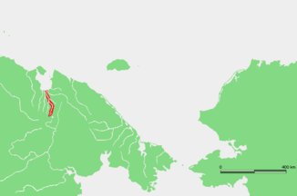
Course of the Tschaun in northern Eastern Siberia |
||
The Tschaun ( Russian Чаун ) is a river in the Chukchi Autonomous Okrug in the extreme northeast of Siberia .
The Tschaun rises on the Anadyr plateau on the northwestern edge of the Elgygytgyn crater . In the upper reaches of the river Maly Tschaun (Ма́лый Чаун, "Little Tschaun") is called. It flows through a sparsely populated tundra landscape in a predominantly northerly direction. Finally the Tschaun reaches the Tschaunbucht on the coast of the East Siberian Sea . The Tschaun and the Paljawaam coming from the east form a common estuary in which their river arms unite and separate again. The Putschewejem flows directly to the west . The main tributaries of the Tschaun are Ugatkyn from the left and Milguwejem from the right. The Tschaun has a length of 205 km. Its catchment area covers 23,000 km².
