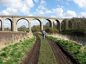
Roxburgh Viaduct
Coordinates: 55 ° 33'59 " N , 2 ° 28'27" W.
| Roxburgh Viaduct | ||
|---|---|---|
| The Roxburgh Viaduct | ||
| use | Railway bridge | |
| Convicted | St Boswells - Tweedsmouth railway line | |
| Subjugated | Teviot | |
| place | Roxburgh | |
| construction | Stone arch bridge | |
| Number of openings | 14th | |
| Clear width | 14.2 m | |
| Clear height | about 21 m | |
| start of building | 1847 | |
| opening | 1850 | |
| closure | 1968 | |
| location | ||
|
|
||
The Roxburgh Viaduct is a former railway bridge in the Scottish village of Roxburgh in the Council Area Scottish Borders . In 1971 the structure was included in the Scottish monument lists in the highest monument category A.
history
The viaduct was from 1847 to 1850 by the North British Railway as part of the railway line between St Boswells and Tweedmouth which the Waverley Line with today's East Coast Main Line built combined. Presumably, C. D. Young & Co. was the executing company. When the line was closed in 1968, the bridge was closed. Today it is part of The Borders Abbeys Pedestrian Way .
description
The masonry viaduct spans the Teviot with 14 lined round arches . The six central arches have a clear width of 14.2 m. The four flanking arches are only 9.1 m wide. The clear height is a maximum of about 21 m. The viaduct consists of roughly hewn quarry stone that was built into layered masonry . Since the railway line describes a wide curve in the area of the Teviot crossing, the viaduct is curved.
Individual evidence
- ↑ a b Listed Building - Entry . In: Historic Scotland .
- ↑ a b Entry on Roxburgh Viaduct in Canmore, the database of Historic Environment Scotland (English)
Web links
- Entry on Roxburgh Viaduct in Canmore, Historic Environment Scotland database

