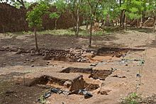
Loropéni ruins
| Loropéni ruins | |
|---|---|
|
UNESCO world heritage |
|

|
|
| Remains of the fortress walls (May 2016) |
|
| National territory: |
|
| Type: | Culture |
| Criteria : | iii |
| Surface: | 1.11 ha |
| Reference No .: | 1225 |
| UNESCO region : | Africa |
| History of enrollment | |
| Enrollment: | 2009 (session 33) |
The ruins of Loropéni are the remains of a former fortification in the municipality of Loropéni in the south of the West African state Burkina Faso , near the border with the Republic of Ivory Coast , Ghana and Togo , in what is now the settlement area of the Lobi people .
description
The ruins are the best-preserved part of a system of ten fortifications that were built to protect the former Trans-Saharan trade . Around the ruins of the fortress of Loropéni, a settlement of around 100 stone buildings has formed over time. The structures were probably built by the Kulango or Loron people, who controlled the extraction and processing of gold during the heyday of the gold trade between the 14th and 17th centuries.
A large part of the facilities has not yet been excavated and knowledge about them is still very little. According to recent research, the ruins are at least 1000 years old. It is unclear why and when the systems were abandoned. The settlement was finally abandoned in the early 19th century.
In June 2009, the ruins of Loropéni became the first object in the country to be included in the list of UNESCO World Heritage . The area designated as World Heritage covers an area of around 1.11 hectares (including a protective buffer zone as much as 278.4 hectares).
See also
Individual evidence
- ^ The Ruins of Loropéni , description by the UNESCO World Heritage Center
Web links
- unesco news with a photo
- Entry on the UNESCO World Heritage Center website ( English and French ).
Coordinates: 10 ° 18 ′ 37 " N , 3 ° 33 ′ 47" W.

