Saint-Léonard (New Brunswick)
| Saint-Léonard | ||
|---|---|---|
 |
||
| Location in New Brunswick | ||
|
|
||
| State : |
|
|
| Province : | New Brunswick | |
| County: | County Madawaska | |
| Coordinates : | 47 ° 6 ′ N , 67 ° 33 ′ W | |
| Height : | 264 m | |
| Area : | 343.95 km² | |
| Residents : | 1343 (as of 2011) | |
| Population density : | 3.9 inhabitants / km² | |
| Time zone : | Atlantic Time ( UTC − 4 ) | |
| Municipality number: | 506 | |
| Postal code : | E3V, E7B | |
| Foundation : | 02104 | |
| Mayor : | Carmel St-Amand | |
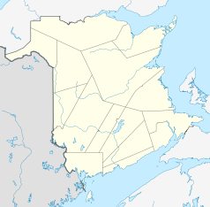
Saint-Léonard is a city in Madawaska County in New Brunswick , Canada . It is located in the northwest of the province at the confluence of the Saint John and Madawaska rivers . The international border between Canada and the United States runs in the middle of the Saint John River; a bridge connects Saint-Léonard with the opposite city of Van Buren in Maine .
The city in 2011 has 1,342 inhabitants, 98% of whom speak French, the highest francophone proportion in the entire province. The city is surrounded by the rolling hills of the Appalachian Mountains, the Madawaska River flows through the city center and flows into the majestic Saint John River in the south. Saint-Léonard is on the Trans-Canada Highway , which leads from Québec to the coast. The main livelihood of the region is the wood industry and the residents find employment in numerous sawmills, paper and pulp mills.
history
The unclear borderline in this area was long disputed between what was then British North America and the United States and almost led to the Aroostook War in 1838/39. The conflict finally ended in 1842 with the Webster-Ashburton Treaty in London without a shot. The Francophone so-called Brayon in the region lived on both sides of the border and wanted to found their own state, the Republic of Madawaska . The mayor of Saint-Léonard still bears the title of President of the Republic of Madawaska and the Madawaska flag flies in front of the town hall.

