
Santa Lucrécia de Algeriz
| Santa Lucrécia de Algeriz | |||||
|---|---|---|---|---|---|
|
|||||
| Basic data | |||||
| Region : | Norte | ||||
| Sub-region : | Cávado | ||||
| District : | Braga | ||||
| Concelho : | Braga | ||||
| Freguesia : | União das Freguesias de Santa Lucrécia de Algeriz e Navarra | ||||
| Coordinates : | 41 ° 36 ′ N , 8 ° 22 ′ W | ||||
| Height: | 215 m | ||||


Santa Lucrécia de Algeriz is a place and a former municipality in the Braga district in Portugal . It has 535 inhabitants (as of June 30, 2011). and an area of 4 km². The population density is 134.2 inhabitants / km². The place is located in the Fojotal , where mainly agriculture is practiced. Originally, Santa Lucrécia was the seat of a vicariate belonging to the diocese of Braga . The community is named after St. Lucretia . The name of the Algeriz river is of Arabic origin and means bell or cow bell .
The localities of Casais, Castelos, Eiró, Garrido, Loural, Monte, Reigada, Salgueiro and Souto belong to the municipality of Santa Lucrécia de Algeriz.
On September 29, 2013, the municipalities of Santa Lucrécia de Algeriz and Navarra were merged to form the new municipality of União das Freguesias de Santa Lucrécia de Algeriz e Navarra . Santa Lucrécia de Algeriz is the seat of this newly formed municipality.
Building of the community
- Church house and courtyard
- Main church
- Chapel of S.Bentinho dos Esquecidos ( the forgotten )
- Chapel of S.Brás,
- Chapel of the court of Bárrio
- Chapel of Sta. Catarina.
Celebrations and folk festivals
- Santa Catarina (first Sunday in September)
- São Tiago ( July 25th )
photos
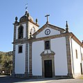
Church of Santa Lucrécia

Individual evidence
- ^ Publication of the administrative reorganization in the Diário da República gazette of January 28, 2013, accessed on October 1, 2014
Web links
- Map of the Freguesia Santa Lucrécia de Algeriz at the Instituto Geográfico do Exército