Santa Rosa de Copan
| Santa Rosa de Copan | |
|---|---|
|
Coordinates: 14 ° 46 ′ N , 88 ° 47 ′ W
Santa Rosa de Copán on the map of Honduras
|
|
|
Location of Santa Rosa de Copán in Honduras
|
|
| Basic data | |
| Country | Honduras |
| City foundation | 1802 |
| Residents | 37,322 (2001) |
| Detailed data | |
| surface | 293.1 km 2 |
| Population density | 127 inhabitants / km 2 |
| height | 1168 m |
| Time zone | UTC −6 |
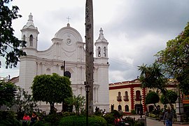
| Santa Rosa de Copán, cathedral | |
Santa Rosa de Copán is located in Honduras in Central America , about 160 km from San Pedro Sula .
The small colonial town has around 28,000 inhabitants and is located at an altitude of 1160 m above sea level . The climate in the region is mild, it gets cool at night and temperatures can drop as low as 12 ° C.
Santa Rosa was mentioned in a document in 1791 and became a county seat in 1812 . The colonial building stock also dates from this time. The tobacco factory is particularly worth seeing. This is where handcrafting takes place for the Flor de Copán cigar brand and other Honduran premium brands. Coffee lovers should visit the Beneficio Maya factory.


