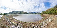
Saritphong Dam
The Saritphong Dam , also Phra-Ruang Dam , ( Thai ส รีด ภ ง ส์, ทำนบ พระร่วง ), is a dam of Sukhotha time origin in the southwest of the UNESCO World Heritage Site Sukhothai in Tambon (municipality) Mueang Kao des Amphoe (district) Mueang Sukhothai des Changwat (Province) Sukhothai in northern Thailand . The Saritphong Dam was built in the 14th century and had the function of damming the main water reservoir for the drinking water supply of the capital of the ancient Kingdom of Sukhothai .
Since the ancient capital, in contrast to its modern successor, located around 13 km to the east, did not have a direct connection to sufficient amounts of water-bearing rivers, the drinking water supply of the historic metropolis had to be done artificially. For this purpose, a dam was constructed in the mountains beginning around three kilometers east of the city between the mountains Khao Kieo Ai Ma and Khao Phra Bat Yai. The construction consisted and consists of a laterite core covered with earth . This construction measure succeeded in catching the water from the mountain streams and the rainfall during the rainy season. From the reservoir created in this way, the water was directed through the Sao-Ho Canal to the city, utilizing the natural slope of the terrain, and from there to a total of four reservoirs ( “Ngoen” (silver), “Thong” (gold), “So” ( Lime pond) and "Tra Kuan" ( water spinach )) distributed inside the city walls. The waste water was disposed of via another, the Mae-Ramphan Canal to the east into the Mae Nam Yom .
In the middle of the 20th century, the dam was renewed and expanded in a cooperation between the Royal Irrigation Department (Department for Irrigation at the Thai Ministry of Agriculture and Cooperatives) and the Fine Arts Department (Ministry of Culture) while preserving the heritage aspects . After this measure it had a length of 487 meters and a thickness of eight meters with a height above ground of 10.5 m. Its stowage capacity is currently around 400,000 cubic meters.
literature
- Dawn F. Rooney: Ancient Sukhothai. Thailand's Cultural Heritage . River Books, Bangkok 2008, ISBN 978-974-9863-42-8 , pp. 71 and 148.
Individual evidence
- ^ Dawn F. Rooney: Ancient Sukhothai. Thailand's Cultural Heritage . River Books, Bangkok 2008, ISBN 978-974-9863-42-8 , p. 148.
- ↑ a b Dawn F. Rooney: Ancient Sukhothai. Thailand's Cultural Heritage . River Books, Bangkok 2008, ISBN 978-974-9863-42-8 , p. 71.
Coordinates: 17 ° 0 ′ 10 ″ N , 99 ° 40 ′ 41 ″ E

