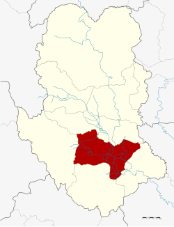
Amphoe Mueang Sukhothai
|
Mueang Sukhothai เมือง สุโขทัย |
|
|---|---|
| Province: | Sukhothai |
| Surface: | 581.474 km² |
| Residents: | 105,715 (2012) |
| Population density : | 185.0 U / km² |
| ZIP : | 64000, 64210, 64220 |
| Geocode : | 6401 |
| map | |

|
|
Amphoe Mueang Sukhothai ( Thai : อำเภอ เมือง สุโขทัย ) is the district of the provincial capital ( Amphoe Mueang ) of Sukhothai Province . Sukhothai Province is located in the northern region of Thailand . The capital of the province is also called Sukhothai .
geography
Neighboring districts (clockwise from southeast): Amphoe Kong Krailat , Khiri Mat , Ban Dan Lan Hoi and Si Samrong in Sukhothai Province and Amphoe Phrom Phiram in Phitsanulok Province .
The main river is the Mae Nam Yom (Yom River).
history
The county was originally the county of the provincial capital of Sukhothai Province and was called "Mueang". In 1917 it was renamed Thani ( ธานี ). In 1932, Sukhothai Province and Sawankhalok Province were merged to form the new Sawankhalok Province. In 1939 the province was renamed "Sukhothai Province". The district of the provincial capital - it was now called Sukhothai Thani ( สุโขทัย ธานี ) - was renamed "Mueang Sukhothai".
economy
- tourism
- Rice cultivation
- Fruit / fruit growing
administration
Provincial Administration
Amphoe Mueang Sukhothai is divided into ten communities ( tambon ) , which in turn are divided into 97 villages ( muban ) .
| No. | Surname | Thai | Muban | Pop. |
|---|---|---|---|---|
| 1. | Thani | ธานี | - | 16,089 |
| 2. | Ban Suan | บ้าน สวน | 14th | 13,901 |
| 3. | Mueang Kao | เมือง เก่า | 11 | 17,450 |
| 4th | Pak Khwae | ปาก แคว | 9 | 9,368 |
| 5. | Yang Sai | ยาง ซ้าย | 12 | 9,756 |
| 6th | Ban Kluai | บ้าน กล้วย | 14th | 17,026 |
| 7th | Ban Lum | บ้าน หลุม | 9 | 8,910 |
| 8th. | Tan Tia | ตาล เตี้ย | 11 | 4,387 |
| 9. | Pak Phra | ปาก พระ | 10 | 3,716 |
| 10. | Wang Thong Daeng | วัง ทองแดง | 8th | 5.112 |
Local administration
Sukhothai-Thani (Thai: เทศบาล เมือง สุโขทัย ธานี ) is a city ( Thesaban Mueang ) in the district, it consists of the entire Tambon Thani.
There are also three small towns ( Thesaban Tambon ) in the district:
- Ban Suan ( เทศบาล ตำบล บ้าน สวน ) consists of parts of the tambon of the same name ,
- Mueang Kao ( เทศบาล ตำบล เมือง เก่า ) consists of parts of the tambon of the same name ,
- Ban Kluai ( เทศบาล ตำบล บ้าน กล้วย ) consists of the entire tambon Ban Kluai.
There are also eight “Tambon Administrative Organizations” (TAO, องค์การ บริหาร ส่วน ตำบล - administrative organizations) for the tambon in the district that do not belong to any city.
Individual evidence
- ↑ ประกาศ กระทรวง มหาดไทย เรื่อง เปลี่ยน ชื่อ อำเภอ . In: Royal Gazette . 34, No. 0 ก , April 29, 1917, pp. 40-68.
- ↑ พระบรม ราชโองการ ประกาศ ยุบ รวม ท้องที่ บาง มณฑล และ บาง จังหวัด . In: Royal Gazette . 48, No. 0 ก , February 21, 1932, pp. 576-578.
- ↑ พระราชกฤษฎีกา เปลี่ยน นาม จังหวัด และ อำเภอ บาง แห่ง พุทธศักราช ๒๔๘๒ . In: Royal Gazette . 56, No. 0 ก , April 17, 1939, pp. 351-353.
- ↑ Population statistics 2012 . Department of Provincial Administration. Retrieved June 25, 2014.
Web links
Coordinates: 17 ° 0 ' N , 99 ° 49' E

