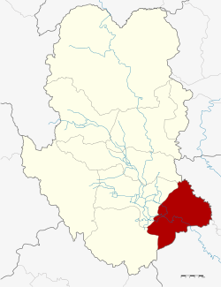
Kong Krailat district
|
Kong Krailat กงไกรลาศ |
|
|---|---|
| Province: | Sukhothai |
| Surface: | 502,382 km² |
| Residents: | 64,719 (2012) |
| Population density : | 128.4 U / km² |
| ZIP : | 64170 |
| Geocode : | 6404 |
| map | |

|
|
Amphoe Kong Krailat ( Thai : อำเภอ กงไกรลาศ ) is a district ( Amphoe - administrative district) in the southeast of the Sukhothai Province . Sukhothai Province is located in the northern region of Thailand .
geography
Neighboring counties (from southwest clockwise): the Amphoe Khiri Mat and Mueang Sukhothai of the Sukhothai Province, and Phrom Phiram and Bang Rakam of the Phitsanulok Province .
history
The county was originally called Ban Krai and was renamed Kong Krailat in 1939.
administration
Provincial Administration
The district is divided into eleven municipalities ( tambon ) , which are further subdivided into 126 villages ( muban ) .
| No. | Surname | Thai | Muban | Pop. |
|---|---|---|---|---|
| 1. | Kong | ก ง | 13 | 5,823 |
| 2. | Ban Krang | บ้าน กร่าง | 12 | 4.143 |
| 3. | Krai Nok | ไกร นอก | 15th | 4,455 |
| 4th | Krai sound | ไกร กลาง | 8th | 3,884 |
| 5. | Krai Nai | ไกร ใน | 15th | 8,068 |
| 6th | Dong Dueai | ดง เดือย | 11 | 6,513 |
| 7th | Pa Faek | ป่า แฝก | 13 | 6,148 |
| 8th. | Kok Raet | กก แร ต | 12 | 5,282 |
| 9. | Tha Chanuan | ท่า ฉนวน | 12 | 10,058 |
| 10. | Nong Tum | หนอง ตูม | 7th | 5,541 |
| 11. | Ban Mai Suk Kasem | บ้าน ใหม่ สุข เกษม | 8th | 4,804 |
Local administration
Kong Krailat (Thai: เทศบาล ตำบล กงไกรลาศ ) is a small town ( Thesaban Tambon ) in the district. It consists of parts of the Tambon Kong, Ban Krang and Pa Faek.
There are also ten "Tambon Administrative Organizations" (TAO, องค์การ บริหาร ส่วน ตำบล - administrative organizations) for the tambon in the district that do not belong to any city.
Individual evidence
- ↑ พระราชกฤษฎีกา เปลี่ยน นาม อำเภอ กิ่ง อำเภอ และ ตำบล บาง แห่ง พุทธศักราช ๒๔๘๒ . In: Royal Gazette . 56, No. 0 ก , April 17, 1939, pp. 354-364.
- ↑ Population statistics 2012 . Department of Provincial Administration. Retrieved June 24, 2014.
Web links
Coordinates: 16 ° 57 ' N , 99 ° 59' E
