
Sassenburg (Schecken)

The Sassenburg (also Sachsenburg) is an early medieval hill fort on the ridge piebald at Hameln in Lower Saxony . The complex, which was probably built as a refuge , was assigned to the time between the 9th and 11th centuries. The builders and users of the fortification with its well-preserved ramparts are not known.
location
The Sassenburg is located about 1.8 km west of Diedersen in the wooded ridge of the Schecken. It is located in the Gutswald of the Diedersen estate, where the ridge has flat slopes to the east. The Wallburg was built on the edge of a steep and deep cut in a stream and is now located in a coniferous forest . It is about 500 meters from Obensburg , which is also regarded as early medieval .
Description and interpretation
The Sassenburg is a circular fortification with a diameter of around 65 to 75 meters and an area of around 0.3 hectares. The interior is on a hillside and has a height difference of around 10 meters. A natural attack protection on the northwest side offered the steep slope to Hellbach with a built-in terrace, whereby the wall height is lower in this area. The other sides of the complex were secured by an eight meter wide wall and, in the interior, by a rampart up to two meters high, which is still completely preserved. The wall is much higher on the outside. In front of the wall is a six meter wide trench that is up to one meter deep. The access to the Sassenburg was through two gateways in the northeast and in the southwest.
About 70 meters south of the facility there was an upstream wall that was 95 meters long. It was six meters wide and three feet high. In the western area it has two openings. The trench in front of the wall was four to six meters wide and less than a meter deep.
The Sassenburg was only discovered in 1932. Mapping took place in 1933. No excavations have been carried out so far. The initial guess is that it is in Sassenburg a ski jump the battle of hastenbeck has acted is by Flurnamen research has since been disproved. It is believed that the complex was built and used between the 9th and 11th centuries. It is hypothetical whether it was, as assumed in the case of the nearby Obensburg, the refuge of an estate from the surrounding area.

Northwestern gate passage from the outside
The ditch in front of the wall

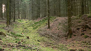
Flat wall on the steep slope edge to the stream


literature
- Hans-Wilhelm Heine : The prehistoric and early historical castle walls in the administrative district of Hanover. Hannover 2000, ISBN 3-7752-5645-8 . P. 92.
Web links
- Entry by Stefan Eismann zu Sassenburg in the scientific database " EBIDAT " of the European Castle Institute
Coordinates: 52 ° 5 ' N , 9 ° 27' E