
Sauvabelin
|
district of Lausanne |
|
|---|---|
 |
|
| Coordinates | 538 651 / 154325 |
| surface | 0.907 km² |
| Residents | 1013 (2018) |
| Population density | 1117 inhabitants / km² |
| structure | |
| district | 13 |
| Quarters |
|
| Source: List of districts of Lausanne | |
Sauvabelin is a district of the Swiss city of Lausanne . It is located in the northern part of the city.
The district itself is in turn divided into two quarters . These are Sauvabelin and Pré-Fleuri. In 2018, around 1013 inhabitants lived in an area of 0.907 km² .
location
The district consists largely of forest areas. Therefore, it is considered a local recreation area for the city of Lausanne and the surrounding area. Many people come to Sauvabelin, especially on Sundays and public holidays.
Public transportation
The bus line 16 of the Transports publics de la région lausannoise crosses the district and has various stops in the area.
Buildings and sights
The main attraction of the district is certainly the Lac Sauvabelin - a small lake in the middle of the forest. The Sauvabelin observation tower is also a popular tourist destination.
gallery

Inn by the lake
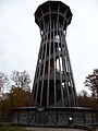
The Sauvabelin Tower

.jpg)

See also
Web links
- Sauvabelin on the Vaud Statistics website
- Site of the observation tower
Individual evidence
Center | Maupas / Valency | Sébeillon / Malley | Montoie / Bourdonnette | Montriond / Cour | Sous-Gare / Ouchy | Montchoisi | Florimont / Chissiez | Mousquines / Bellevue | Vallon / Béthusy | Chailly / Rovéréaz | Sallaz / Vennes / Séchaud | Sauvabelin | Borde / Bellevaux | Vinet / Pontaise | Bossons / Blécherette | Beaulieu / Gray / Boisy | Zones foraines