Zones foraines
|
Zones foraines district of Lausanne |
|
|---|---|
| Coordinates | 543878 / 159522 |
| surface | 23.137 km² |
| Residents | 4375 (2018) |
| Population density | 189 inhabitants / km² |
| structure | |
| district | 90 |
| Quarters |
|
| Source: List of districts of Lausanne | |
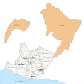
Zones foraines ( German : forest zone ) is a district of the Swiss city of Lausanne . It is located in the north of the city.
The district itself is in turn divided into three quarters . These are Les Râpes, Montheron and Vernand. In 2008, around 3,152 inhabitants lived in an area of 19.235 km² .
location
The foraines zone is by far the largest district of Lausanne in terms of area. The three quarters are not delimited with borders like all the others, but only roughly divided according to region. Most of the area is settled with forest.
Public transportation
Bus routes 60 and 62 of the Transports publics de la région lausannoise connect a small part of the area with the city.
Buildings and sights
The large area of forest is used for recreation, especially on weekends. Since the Sauvabelin recreational area is more touristic and relatively small, hikers often come here.
See also
Web links
- Zones foraines on the Vaud Statistics website
Individual evidence
