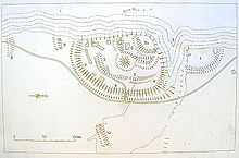
Jumps in the Westerholz
The two ski jumps in Westerholz ( Auf der Burg ) are located about two kilometers south of the castle ruins of Halteberg on the Lechrain in the Landsberg am Lech district ( Upper Bavaria ). The Burgplatz was already in use in the Bronze Age and expanded in the Early and High Middle Ages.
history
Fragments found in the area of the small hill were dated to the Bronze, Latène and Roman times.
Towards the end of the early Middle Ages , the Große Schanze was expanded to its present size. The complex has some typical features of a smaller Hungarian fortress , but it could have been a manor or fortified courtyard.
The small core work on the slope edge and the - still manageable - size of the castle speak for the function as a residence. Characteristics of the Hungarian period are the approach obstacles, the heaped outer rampart and the - later broken - penultimate rampart in front of the core work. In 1999, the author Michael Weithmann interpreted the large hill as a Hungarian state castle . The relatively small size of the complex compared to other presumed state castles, however, suggests a secondary fortification of this period. On the western side of the Lech, the Haldenburg near Schwabmünchen is one of the most impressive early medieval large castles in the region.
The large hill is the southernmost link of an early medieval chain of castles on the Lechrain between Thierhaupten and Kaufering. This line of fortification could have been created before the Hungarian Wars to secure the border between the Alamanni and Bavarian regions .
In the High Middle Ages the castle clearly served as a residence. The small tower hill that was placed on the main wall speaks in favor of this. A few years ago there were a few smaller tufa blocks around the hill , which have now disappeared.
In the first half of the 20th century, a hunting lodge with a few outbuildings was built into the ramparts. The fixtures have now disappeared except for a few floor coverings.
Both jumps are stations of the prehistory and early history trail of the Landsberg am Lech district.
description
The fortifications are separated by a deep erosion channel, which enables an ascent to the plateau. To the north of this incision, the area of the Kleine Schanze is separated from the fore area by an arched moat. The wall is only a maximum of one meter high, the moat has only been preserved as a shallow hollow. The area is densely overgrown with thorn bushes and is only accessible in winter.
A similar - but much more extensive - moat has been partially preserved inside the large hill. The exact time of these two oldest fortifications is unclear.
The Große Schanze is located south of the erosion channel on the slope edge. A rampart up to four meters high with a trench runs from the head of the channel to the steep slope. To the south of the outer bailey there is an additional obstacle to the approach at the demolition edge. The short moat is up to three meters high and about ten meters long. The plan on the board at the castle entrance shows another piece of rampart in front of it, but this has been largely removed by the construction of the road. To the east of the Große Schanze there is still a 40 meter long moat that has been planted with young forest and is therefore difficult to see.
In front of the old gate gap on the east side there has been a plaque with an overview plan and explanations about the history of the castle since 1984.
Behind the ramparts lies the low moat of the prehistoric fortifications. This is followed by the main wall, which can be interpreted as the "Hungarian Wall", to which a tower hill was presented in the high medieval period. The earth material of the wall was obviously reused for this, so that the wall behind the hill is interrupted. Another tower point is at the southern wall end, the northern end is slightly elevated and widened.
The tower hill in front of the main wall is about 4.5 meters high. The summit plateau can only have supported a modest tower. The earth cone is one of the smallest of its kind.
The last earthworks follow the trench and wall of the core work. The arched wall crown increases the interior space by about one meter, the west side is threatened by the progressive soil erosion.
The Bavarian State Office for Monument Preservation lists the two ground monuments as fortifications with ramparts and moats, presumably from the Bronze Age, the Hallstatt Age, the Latène Age, the Roman Empire and the Middle Ages under monument number D 1-7831-0030.
literature
- Michael Weithmann: Knights and Castles in Upper Bavaria - Forays into the medieval country between the Alps, Danube, Lech and Salzach . Dachau 1999, ISBN 3-89251-276-0 ( refuges and refuges in Hungary of the 10th century , pp. 40-46).
Individual evidence
- ↑ Bavarian State Office for Monument Preservation: Entry ( Memento from January 30, 2016 in the Internet Archive )
Coordinates: 48 ° 7 '17.8 " N , 10 ° 51' 35.3" E
