
Schanzerkopf
| Schanzerkopf | ||
|---|---|---|
 South view |
||
| height | 643.5 m above sea level NHN | |
| location | Rhein-Hunsrück-Kreis , Rhineland-Palatinate ( Germany ) | |
| Mountains | Soonwald ( Hunsrück ) | |
| Coordinates | 49 ° 57 '34 " N , 7 ° 38' 12" E | |
|
||

The Schanzerkopf in the Soonwald is 643.5 m above sea level. NHN the highest point of the local community Argenthal in the Rhineland-Palatinate Rhein-Hunsrück district . The peak is fenced, a 80-meter radio tower of reinforced concrete is on the survey of 49 ° 57 '33 " N , 7 ° 38' 12" O . The north slope is used for tobogganing in winter, a 400 m long steep toboggan run attracts winter sports enthusiasts from all over the area. From the summit there is a good view to the north over the Hunsrück . Another transmitter mast has been on the summit since 2008. In the 1960s, winter sports enthusiasts from Ellern built a small ski lift on their own, which enjoyed great popularity, but was shut down at the end of the 1970s because it no longer met current regulatory requirements.
The source streams of the Graefenbach arise south of the summit .
More transmitter masts on the Schanzerkopf
By 2020, five transmitter masts including the above-mentioned transmitter masts had been installed on the Schanzerkopf. Two reinforced concrete masts are used for air traffic control. Two more are used for communication and are used by telecommunications companies for cellular and broadband technology. Another transmission mast is under military use.

overview

Militarily used transmission mast
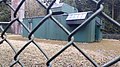
Broadcasting house of the transmission system
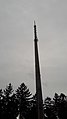
Reinforced concrete mast

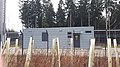
Technical room

Cell tower

Plant room
Broadcasting house


Web links
- soonwald.de
- https://emf3.bundesnetzagentur.de/karte/
- https://www.google.de/maps/place/Schanzerkopf/@49.9593981,7.6353978,167m/data=!3m1!1e3!4m5!3m4!1s0x47be085bbf59dd71:0x3adfc03530ef2ab9!8m2!3d49.959347!4d7.636717
Individual evidence
- ↑ a b Map service of the landscape information system of the Rhineland-Palatinate Nature Conservation Administration (LANIS map) ( notes ) Scale 1: 3,000
- ↑ [1]