Scherlebeck
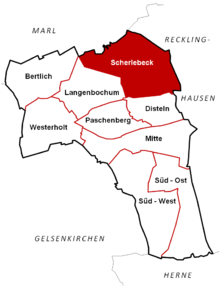
Scherlebeck is the northernmost district of the city of Herten in the Recklinghausen district .
history
The place was characterized by a village until the beginning of industrialization. On August 1, 1898 to work on the shaft 5 has been mining iron mallets & started a year later were discovered at a depth of 412 m on coal . The colliery operation started normally in 1901 and ended with the cessation of production in 1996, the backfilling of the shafts followed in 1999. Despite the reuse of the former colliery areas by u. a. Retirement homes, kindergartens and service providers have shaped the district to this day by the mining era, not least because of the large number of colliery settlements. Only the recreation area "Die Ried" to the north of the settlements on the city limits of Marl / Recklinghausen , with its rural structure and old farms, gives an idea of Scherlebeck's original landscape.
Politics / administration
The place used to belong to the municipality of Recklinghausen-Land . When this was dissolved on April 1, 1926, Scherlebeck was incorporated into Herten, where it now forms one of the nine districts.
Web links
- Scherlebeck colliery
- Scherlebeck in the Westphalia Culture Atlas
Coordinates: 51 ° 37 ' N , 7 ° 9' E

