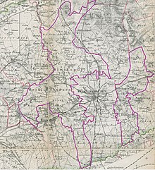
Recklinghausen-Land
The municipality of Recklinghausen-Land , also known as the parish Recklinghausen in the 19th century , was a municipality in the Recklinghausen district in the Prussian province of Westphalia until 1926 . It included parts of today's cities of Herten , Marl , Oer-Erkenschwick and Recklinghausen .
geography
The Recklinghausen-Land community consisted of two spatially separated parts. The larger part of the area extended to the west and north of the city of Recklinghausen and comprised the farmers Bockholt , Disteln (with Backum ), Ebbelich, Hochlar , Hochlarmark , Langenbochum , Lenkerbeck , Löntrop (with Hüls and Korthausen), Scherlebeck , Speckhorn (with Börste) and Stuckenbusch . The smaller part of the area, which stretched east of the city of Recklinghausen, consisted of the four farmers Berghausen , Erkenschwick , Essel and Röllinghausen . In 1895 the community had an area of 68.4 km².
history
The community Recklinghausen-Land emerged from the old parish Recklinghausen . Since 1844 it belonged to the Recklinghausen office in the Recklinghausen district. In the second half of the 19th century, several large coal mines emerged in the municipality, which led to a sharp increase in population.
The community was dissolved on April 1, 1926 by the law on the reorganization of the communal borders in the Rhenish-Westphalian industrial districts . Berghausen, Bockholt, Börste, Essel, Hochlar, Hochlarmark, Röllinghausen, Speckhorn and Stuckenbusch came to the city of Recklinghausen, Hüls, Lenkerbeck and Löntrop came to the municipality of Marl, Scherlebeck, Disteln, Ebbelich and Langenbochum came to the municipality of Herten and Erkenschwick came to the municipality of Oer- Erkenschwick .
Mining
In the municipality of Recklinghausen-Land there were, among others, the Ewald coal mine in Erkenschwick, King Ludwig in Röllinghausen, Recklinghausen in Hochlarmark and Schlägel & Eisen in Thistles.
Population development
| year | Residents | source |
|---|---|---|
| 1833 | 3,792 | |
| 1858 | 3,693 | |
| 1871 | 3,779 | |
| 1885 | 5,407 | |
| 1895 | 8,776 | |
| 1910 | 41,087 |
Individual evidence
- ^ A b Statistical news about the government district of Münster, 1860
- ↑ a b Genwiki: Landgemeinde Recklinghausen
- ^ Official Journal of the Münster government 1844: Formation of the Recklinghausen office
- ↑ Stephanie Reekers: The regional development of the districts and communities of Westphalia 1817-1967 . Aschendorff, Münster Westfalen 1977, ISBN 3-402-05875-8 , p. 274 .
- ^ Westphalia Lexicon 1832-1835 . In: Landschaftsverband Westfalen-Lippe (Ed.): Reprints for the Westphalian archive maintenance . tape 3 . Münster 1978, p. 249 (reprint of the original from 1834).
- ↑ 1871 census
- ^ Community encyclopedia for the province of Westphalia 1885
- ↑ Uli Schubert: German municipality register 1910. Retrieved on April 22, 2014 .
Coordinates: 51 ° 36 ' N , 7 ° 10' E
