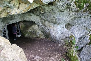
Schiller cave
| Schiller cave
|
||
|---|---|---|
|
Entrance to the Schiller Cave |
||
| Location: | Baden-Wuerttemberg , Germany | |
| Height : | 660 m | |
|
Geographic location: |
48 ° 28 '10.7 " N , 9 ° 25' 36.4" E | |
|
|
||
| Geology: | Shell limestone | |
| Overall length: | 245 m | |
| Level difference: | 30 m | |
The Schiller Cave , also called Schillingsloch , in the Bad Urach district of Wittlingen on the Swabian Alb is named after Friedrich Schiller or a Mr. von Schilling who was killed there while hunting a bear in 1341. In 1833 the Urach forester Friedrich von Mandelsloh carried out excavations in the cave and found the bones of brown bears and lynxes as well as a well-preserved human skull. He did not look for traces of settlement.
The cave was described under the fictional name Tulkahöhle in the book Rulaman by David Friedrich Weinland , where it is said to have been the living cave of a tribe of Stone Age people. An actual settlement of the cave in the Stone Age has not yet been proven.
There was a natural bridge in front of the cave entrance, which collapsed in May 2009. Access was then blocked for a few months.
The cave is closed during the bat protection period .
literature
- Hans Binder , Herbert Jantschke: Cave guide Swabian Alb. Caves - springs - waterfalls . 7th completely revised edition. DRW-Verlag, Leinfelden-Echterdingen 2003, ISBN 3-87181-485-7 , p. 111 .
Web links
- Jochen Duckeck Schiller Cave or Schillings Cave .
- Schiller cave , website of the city of Bad Urach.
- Carmen Rausche: Hohen Wittlingen and Schiller Cave
- Wilhelm von Gümbel: Mandelsloh, Friedrich Graf von . In: Allgemeine Deutsche Biographie (ADB). Volume 20, Duncker & Humblot, Leipzig 1884, p. 171 f.
Individual evidence
- ↑ a b Thilo Müller: Schiller cave. Arge Grabenstetten, January 2011, accessed on August 5, 2019 .


