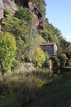
Arzviller lock staircase
The Arzviller lock staircase is part of the Canal de la Marne au Rhin (Rhine-Marne Canal) in the Moselle department in Lorraine . In the 1960s it was replaced by the nearby ship lift (inclined lift ) Plan incliné de Saint-Louis / Arzviller . The system has largely been preserved.
location
The lock staircase begins on the eastern outskirts of Arzviller , where the new canal branches off and leads to the boat lift on the southern slope of the narrow Teigelbach valley. The lock staircase winds down the northern slope and reaches the Zorn valley floor at Hofmuehle .
history
Construction of the Canal de la Marne au Rhin began in 1838. The work on the slope of the narrow valley turned out to be difficult, in some places had to be dug into the sandstone on the slope side, but bricking towards the stream. In several places, the canal floor had to be poured from concrete for the sake of tightness. From 1844 to 1846 work was interrupted due to the construction of the Paris – Strasbourg railway line , and from 1848 to 1851 the construction site was idle again.
On September 7, 1853, water was let in for the first time. In the intermediate sections 9 and 13 leakage problems occurred, but these could be eliminated quickly. On September 22nd, 1853, the lock staircase was put into operation. In October and November of that year there were breaks in sections 9 and 10, which required regular checks on these points.
After the Franco-Prussian War , this section of the canal became part of the German Empire . The German government continued to rebuild the canal according to Freycinet dimensions so as not to lose the French markets.
In a preliminary study in 1921 it was initially determined that there was hardly any possibility of expanding the facility in the narrow valley of the Teigelbach. Possible alternative routes would have required a high proportion of engineering structures, especially tunnels and canal bridges . The decision ultimately made to fundamentally rebuild the old facility was not implemented.
Until the beginning of the 20th century, barges were pulled by two to four horses or mules , then electric towing became popular . On the valley side of the lock staircase, remains of the track and sheds of the towing locomotives can still be seen. From 1933 self-propelled ships prevailed.
The lock keepers lived directly at the locks. In addition to the locks on the ships, they were responsible for monitoring the functionality and safety as well as maintaining the lock chambers, the mechanical systems and the dikes. The working hours were more than eleven hours a day, seven days a week. In winter, the canal stairs were emptied for repair work.
It took a whole day to go through the lock stairs. The system also needed a lot of water, which led to problems in dry summers. In 1969 the system was therefore replaced by the nearby Saint-Louis / Arzviller ship lift . Between the Arzviller tunnel and lock 1, the new canal branches off to Plan incliné from the apex position , the junction is in front of lock 18 in the valley of the Zorn .
description
Between Arzviller and the valley of the Zorn, a height difference of 44.55 meters was overcome by means of a series of 18 locks over a length of 4 kilometers. The difference in height per lock is 2.60 meters. The lowest lock No. 18 at a height of 221.73 meters ( Marseille gauge ) is still in operation.
Initially, each lock chamber was 33.85 meters long, 5.20 meters wide and 1.60 meters deep. From 1879 the canal was adapted to the uniform Freycinet dimensions : by extending it uphill, the locks were given a usable length of 38.50 meters, the fairway was initially deepened to 2.00 meters, and in 1895 to 2.20 meters.
The locks, which are laid out at almost identical intervals, are numbered consecutively from top to bottom (numbers 1 to 18). They are on average about 180 meters apart, the shortest intermediate section is 45.10 meters between locks 2 and 3. The intermediate sections (biefs) bear the number of the lock following down the slope. The curve radii of the winding system are between 60 and 200 meters.
In order to hold water, the canal is extended to holding basins at three points, where it is fed by side waters. Most of the lock stairs still carry water, only the lower area is partially drained.
At lock 14, the parallel Paris – Strasbourg line is crossed. The old towpath is mostly paved and has been largely used as a footpath and bicycle path since 2007. Between the locks 15 and 16 it leads through the canal in an elevated position.
Each lock has a lock keeper's house, the majority of which are still there. Today they are used as residential buildings, especially in the upper part of the complex.
gallery
Web links
- Bord à Bord: La descente des Vosges, de l'échelle d'écluses au plan incliné d'Arzviller , detailed documentation (French) with many maps, plans and historical photos, accessed on November 10, 2013
- Randonnées ferroviaires : photo of lock 14 with the peniche pulled by a towing engine
Individual evidence
- ↑ Lorraine cycle routes greenways (French) , accessed on November 11, 2013
Coordinates: 48 ° 43 ′ 28 ″ N , 7 ° 12 ′ 1 ″ E


