
Saint-Louis / Arzviller boat lift

The ship lift Saint-Louis / Arzviller ( German actually Schiffshebewerk St. Ludwig / Arzweiler , French Plan incliné de Saint-Louis / Arzviller ) is part of the Rhine-Marne Canal . It has been in operation since 1969 and replaces 17 locks between Saint-Louis and Arzviller in Lorraine and the Zorn Valley , with a difference in altitude of 44.55 m .
technology


The system is a ship lift with wet lift ; The core is a trough mounted on rollers, held by ropes and balanced with two counterweights. The trough is 41.50 m long and 5.50 m wide. The water depth is 3.20 m; the trough filled with water weighs around 900 tons. It is moved by electrically driven winches on an inclined plane with a gradient of 41% perpendicular to its greatest extent. The incline connects the uphill canal that comes from Nancy with the downhill canal that continues towards Strasbourg .
During the descent, the trough is filled with so much water that its weight is slightly greater than that of the counterweights . Conversely, for the ascent, some water is drained into the valley-side channel so that the trough is slightly lighter than the counterweights. Two electric motors , each with an output of 88 kW (120 PS), which are connected as Ward-Leonard converters , are therefore sufficient to drive the trough . The acceleration when starting and braking is 0.02 m / s 2 and the maximum speed 0.60 m / s.
When the trough arrives at the valley or mountain station , the space between the trough and the channel is first closed by a movable sealing frame. The trough and canal gates are then raised, allowing ships to enter and exit. Before departure, the two gates are lowered again and the space in between is emptied by opening a slide. Then the sealing frame is lifted off again and the trough can start moving.
The time from the entrance on the mountain side to the exit on the valley side is around 25 minutes, of which four minutes are allotted to the journey of the trough. The elevator is able to lock around 40 cargo ships per day and direction. Since a recent repair, the driving time is 18 minutes plus entry / exit, making a total of 40 minutes. According to the lock keeper, a renewed gear causes loud running noises at higher speeds.
Apart from this ship lift, only two similar constructions with inclined lifts are in operation worldwide. The one in Ronquières in Belgium ( Ronquières ship lift ) on the Charleroi-Brussels canal works on the same principle, except that the troughs are built lengthways, while the St. Louis-Arzviller lift pulls the trough up across the direction of travel. The boat lift on the Krasnoyarsk Reservoir in Krasnoyarsk on the Yenisei River in Russia can be described as an oversized rack railway.
construction
The 1853 opened Rhein-Marne-channel had the height difference between the summit level in the Vosges and the Zorntal along the Teigelbachtals with a lock staircase km overcome by 17 locks on a length of the fourth Because of the narrow radii of curvature and the short damming of the canal in this area, the Arzviller lock staircase was a dreaded bottleneck for shipping. Expansion of the canal in this area was made difficult by the narrowness of the valley and existing viaducts on the Paris – Strasbourg railway line.
In 1962 a competition was announced with the condition that the lock staircase should be replaced by a single structure in the proposed solutions. The draft that was finally implemented had to prevail against 39 other proposals drawn up by nine different providers.
The construction phase lasted from 1964 to 1969 and, in addition to the construction of the actual ship lift, also included the canal connections to the existing canal. On the mountain side, a 3.3 km long canal was built on a hillside to extend the apex position; On the valley side, a new section 1 km long in the valley floor of the Zorn valley was sufficient. The elevator was designed in such a way that it could later be extended by a trough for tandem operation. At that time there was no modern predecessor for a ship lift with cross conveyor, so that the entire project also had an experimental character. The boat lift was opened to traffic on January 27, 1969, reducing the travel time on the Strasbourg – Nancy route by one day.
economic aspects
At the time of construction, the boat lift was seen as an important technical advance that should make trade much easier. The personnel savings of two operating engineers compared to 17 lock keepers should cover the operating costs of the elevator. Soon afterwards, however, freight transport by road and rail became so much cheaper that freight transport on the Rhine-Marne Canal became unprofitable. The second trough was therefore never built. Today the descent structure is mainly used by recreational boaters. However, the boat lift generates significant income from tourism by offering guided tours and boat tours.
Accidents and shutdowns
On July 4, 2013 there was an accident with the excursion boat Paris without personal injury , as a result of which several thousand cubic meters of water flowed out of the upper channel and the tub in the upper position. Due to the threat of flooding, the nearby town of Lutzelbourg was evacuated for several hours. The lift was initially out of order for an indefinite period.
Operation was resumed on April 30, 2014, but stopped again on July 10, 2014 because important parts of the drive were defective. The elevator has been in operation again since August 3, 2015.
More pictures

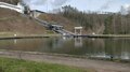
Overview picture from below
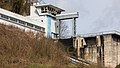
View from below of the upper lock gate

Trough on the way

Trough in upper position
Video


Individual evidence
- ↑ reprise du trafic incliné au plan. Retrieved June 5, 2019 (FR-FR).
- ↑ Kerstin Joost-Schäfer: Where ships lie in the tub . In: Saarbrücker Zeitung from 18./19. June 2011, p. H6.
- ↑ L'Alsace, August 7, 2013 , accessed August 18, 2014.
- ↑ Note on the operator's website , accessed on August 18, 2014.
- ↑ Le plan incline d'Arzviller remonte la pente .
- ↑ Avarie au plan incline d'Arzviller: nouvelle fermeture de l'ouvrage .
- ↑ Fermeture du plan incline d'Arzviller: une catastrophe économique et touristique .
swell
- Revue de la Navigation Fluviale Européenne Ports et Industries; Special edition dated June 25, 1970.
Web links
- Operator's website
- Arzviller's parents' association: ship lifts, crystal factories, former life in Arzviller ... ( Memento of February 27, 2014 in the Internet Archive )
Coordinates: 48 ° 42 ′ 59 ″ N , 7 ° 13 ′ 9 ″ E