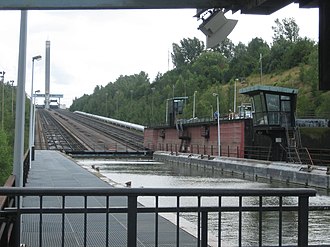
Ronquières boat lift
The Ronquières ship lift ( French Plan incliné de Ronquières ) is located in the Belgian province of Hainaut ( French Hainaut ) in the Wallonia region . It was built between 1962 and 1968 and named after the village of Ronquières at its lower end . The boat lift replaces 14 locks on the Charleroi – Brussels Canal .
history
The Charleroi – Brussels Canal, opened in 1832, has been navigable between Charleroi and Clabecq for 300 ton ships ( Pénichen ) since 1914 . The biggest obstacle for navigation was always the section Ronquières-Godarville running through the valley of the Samme , on which a height difference of almost 70 meters had to be overcome by means of numerous curves, 14 locks and a tunnel. Driving through this section took one to two days.
After the Second World War, the Belgian government decided to expand the full length of the canal for 1,350-tonne ships ( European ships ). Therefore this section had to be completely redrawn. In addition, the section should not be overcome through locks, but a ship lift .
Even at the time the ship lift opened, the transport of goods on the canal decreased significantly due to the decline of the coal and steel industry in the Greater Charleroi area. Between 1987 and 1997, only around 1 million tons of goods were transported via the ship lift per year. From then on, however, the transported tonnage increased again significantly, so in 1999 almost 1.6 million tons were transported. Just one year later, the limit of 2 million tons was exceeded. From 2002, the new Strépy-Thieu boat lift in the Canal du Center made it possible for European ships not only to travel to Charleroi but also to cross the watershed between the Meuse and the Scheldt. In 2007 the Ronquières ship lift then transported a little more than 3 million tons of goods.
technology
The Ronquières ship lift is a double inclined lift with longitudinal and wet conveying . The incline is 1.432 kilometers long and overcomes a difference in altitude of 67.73 meters.
The two troughs each have their own counterweight of 5,200 tons and therefore work completely independently of one another. The troughs are each connected to their counterweights by 8 steel cables and are driven according to the principle of traction sheave conveyance. They are 91 meters long and 12 meters wide. The water depth in the trough can vary between 3.0 and 3.7 meters.
Under each of the two troughs, two tracks are concreted into the incline with a gauge of 1700 mm, on which the 236 wheels with a diameter of 700 mm run. The identical wheels of the counterweights run on rails with a track width of 3000 mm.
With a top speed of 1.2 m / s, the pure travel time between the two ends is around 22 minutes. Including the times for opening and closing the gates and the docking and casting off maneuvers, a ship needs about 50 minutes to pass through the entire facility.
tourism
When the ship lift was planned, it was also considered to be used for tourism. A visitor center is located in the upper machine house. You can watch the lift work from the viewing terrace, and there is an exhibition on the history of Belgian inland navigation in the basement. The striking 150 meter high tower above the upper machine house carries the control room on its 6th floor, around a quarter of its total height. Otherwise it has no technical significance, it only serves as a lookout tower . From the lower end of the elevator, excursion boats drive over the elevator in summer.
festival
The Ronquières Festival has been held around the top of the elevator every year on the first weekend in August since 2012 . It is a music festival where both Belgian and international rock and pop musicians perform.
literature
- Hans-Joachim Uhlemann: The history of the ship lifts . DSV-Verlag, Hamburg 1999, ISBN 3-88412-291-6 .
Web links
- Ronquières boat lift. In: Structurae - with photos
Individual evidence
- ^ Direction générale des Voies hydrauliques, Statistiques
- ↑ The inclined plane of Ronquières ( Memento of the original from June 11, 2008 in the Internet Archive ) Info: The archive link was inserted automatically and has not yet been checked. Please check the original and archive link according to the instructions and then remove this notice.
- ^ Ronquières Festival. Historique. Retrieved February 9, 2018 (French).
Coordinates: 50 ° 35 ′ 52 ″ N , 4 ° 13 ′ 18 ″ E


