Schnappenberg
| Schnappenberg | ||
|---|---|---|
|
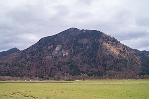
Schnappenberg with Schnappenkirche from the west |
||
| height | 1260 m above sea level NN | |
| location | Chiemgau , Bavaria , Germany | |
| Mountains | Chiemgau Alps | |
| Coordinates | 47 ° 45 ′ 47 " N , 12 ° 29 ′ 12" E | |
|
|
||
The Schnappenberg is a 1260 meter high mountain in front of the Hochgern to the northwest between Marquartstein and Staudach-Egerndach in Chiemgau .
The fully wooded summit is difficult to access and is not a worthwhile excursion destination in itself. Below the summit, however, there is the Schnappenkirche at an altitude of 1100 meters . This is along one of the ascent routes to Hochgern and can be reached as an easy hike from Marquartstein in around 90 minutes. From there, when the weather is clear, there is a good view to the north of Grassau and the Chiemsee .
The ascent from the wood storage area in Staudach requires surefootedness in wet weather in some places and has not been maintained in recent years. This route takes about 70 minutes.
Forest fires, some of which were devastating, broke out on the western slope of the Schnappenberg in 1881, in March 1933 and in December 1972.
literature
- Wilfried Bahnmüller: Hiking in the Chiemgau . DuMont Reiseverlag, Ostfildern, ISBN 3-7701-5967-5
Web links
- Schnappenkirche Church on the Schnappenberg ( Memento from May 12, 2009 in the Internet Archive )


