Schokalski Island (Kara Sea)
| Schokalski Island | ||
|---|---|---|
| Waters | Kara Sea | |
| Geographical location | 73 ° 1 ′ N , 74 ° 26 ′ E | |
|
|
||
| length | 30 km | |
| width | 20 km | |
| surface | 426.4 km² | |
| Highest elevation | 27 m | |
| Location in the Kara Sea | ||
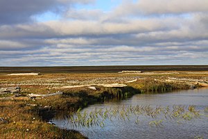
The Schokalsky Island ( Russian Остров Шокальского , Ostrow Schokalskowo ) is a Russian island in the southern Kara Sea . Administratively it belongs to the Yamal-Nenets Autonomous Okrug in Tyumen Oblast . The island is named after Juli Michailowitsch Schokalski , a Russian oceanographer and cartographer and president of the Russian Geographical Society .
geography
The Schokalski Island is located at the eastern end of the Obbusens , as a direct continuation of the northwestern part of the Gydan Peninsula . It is separated from this by the Gydanski Strait ( Гыданский пролив ), which is only a few kilometers wide and interspersed with numerous small islands . However, since this is icy almost all year round, the island is effectively connected to the mainland. The Schokalski Island is almost 30 km long, up to 20 km wide and has an area of 426.4 km². The island, shaped by tundra , is mostly flat and reaches a height of only 27 m above sea level. The island is part of the 1996 decorated Sapowedniks Gydan , one of the larger protected areas of Russia.
Individual evidence
- ↑ a b UNEP Islands Directory (English)
- ↑ Gydan-Sapowednik in the information and information system Specially Protected Natural Areas of Russia of the Center for Nature Conservation (Russian)
Web links
- Article Schokalsky Island (Kara Sea) in the Great Soviet Encyclopedia (BSE) , 3rd edition 1969–1978 (Russian)


