Schunter cycle path
The Schunter Cycle Path is a 70 km long cycle path along the Schunter in southeastern Lower Saxony . It leads from the mouth of the river into the Oker near Groß Schwülper upstream to the source in the Elm near Räbke .
The route has two variants. The cycle path is 71 km long and has 340 meters , according to other information, 360 meters . Most of the route is on asphalt and gravel. The 74 km long variant with an altitude difference of 380 meters is designed as a trail and is intended for bikes with good riding technique and wide tires.
The route mostly runs near the river. Interesting on the route include the Scheverlingenburg in Walle, the Borwall which Schunterdüker the Midland Canal , the rehabilitated river range Dibbesdorf and Hondelage , the windmill Wendhausen , the castle Wendhausen that Schunteraue in Ochsendorf , the stone chamber of large Steinum and the watermill Liese Bach in Räbke.
The cycle path is not signposted. Route navigation is possible using a mobile app and maps.
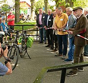
The cycle path was officially released in May 2019 in Räbke at the kick-off event of the Schunter water week .
See also
Web links
- Description at elm-freizeit.de
- Two-page flyer with route and presentation of sights , pdf
- Tour overview of the cycle path with map and photos , pdf
- Tour overview of the trail with map and photos , pdf
Individual evidence
- ↑ Toni Korporal: Schunter Water Week: Why a small river means a lot in Helmstedter Nachrichten of May 19, 2019

