Seabee Hook
| Seabee Hook | ||
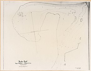
 Topographic map of the Hallett Peninsula (center right) with Seabee Hook near Cape Hallett |
||
| Geographical location | ||
|
|
||
| Coordinates | 72 ° 19 ′ S , 170 ° 13 ′ E | |
| location | Victoria Land , East Antarctica | |
| coast | Borchgrevink coast | |
| Waters | Moubray Bay | |
| Waters 2 | Edisto Inlet | |
 |
||
The Seabee Hook is a flat, hook-shaped headland made of coarse volcanic ash on the Borchgrevink coast of the East Antarctic Victoria Land . It is located 800 m west of a high and rocky ridge that forms Cape Hallett on the northern foothills of the Hallett Peninsula .
Participants in the first Operation Deep Freeze of the United States Navy took a survey from aboard the icebreaker in January 1956 USCGC Edisto ago. Named the headland is by the English phonetic shorthand of " c onstruction b attalions", the construction crews of the US Navy .
Web links
- Seabee Hook in the Geographic Names Information System of the United States Geological Survey (English)
- Seabee Hook on geographic.org (English)
