
Bensheim glider airfield
| Bensheim glider airfield | |
|---|---|

|
|
| Characteristics | |
| Coordinates | |
| Height above MSL | 95 m (312 ft ) |
| Transport links | |
| Distance from the city center | 1 km east of Schwanheim, a good 3 km west of Bensheim |
| Street | L3345 |
| train | Bensheim station |
| Local transport | Bus route 676 from the bus station |
| Basic data | |
| opening | 1958 (reopened in 1976) |
| operator | Segelfluggruppe Bensheim eV |
| Flight movements |
2133 (2006) |
| Runways | |
| 14L / 32L (runway) | 980 m × 30 m grass |
| 14R (runway) | 250 m × 30 m grass |
| 32R (runway) | 250 m × 30 m grass |
The Bensheim glider airfield is officially called Bensheimer Stadtwiesen, which allows conclusions to be drawn about the property (city) and its earlier use (= Bleichwiesen am Winkelbach, which used to meander here in the former Neckar bed). The grass area in Bensheim , which was last leveled, straightened and raised flood-proof in 2006, lies between the Bensheim industrial park Schwanheimer Straße and the Schwanheim district . Gliders , motor gliders and powered airplanes land here regularly . There are several halls / hangars and the club building on the airfield site .
Flight movements
In 2006 there were a total of 2133 aircraft movements, of which 1567 glider starts (of which 1119 winch starts) and 263 motor glider starts. In addition, 118 motorized flights were organized for sightseeing, maintenance or instruction flights. In 2018, 301 flights with a total distance of 82,862 km were evaluated in the nationwide 'Online Contest'.
photos

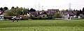
The location of the airfield between Bensheim and the Schwanheim district

The powered aircraft AVIAT HUSKY for short D-ELMY landing. In the background the two steeples of the Schwanheim Church.
A glider is being towed by a powered airplane


Web links
Individual evidence
- ↑ Segelflugszene gGmbH: Statistics: Association OLC 2018 - Germany. Retrieved March 11, 2019 .